You are here: Home > Network List > II - Global Seismograph Network (GSN - IRIS/IDA) Stations List
> Station PFO Pinon Flat, California, USA > Earthquake Result Viewer
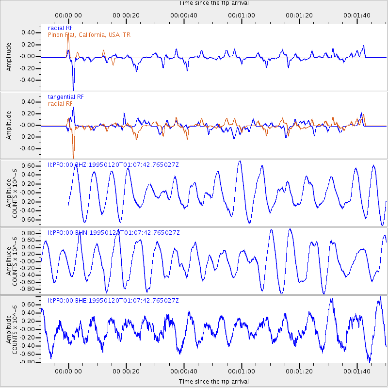
PFO Pinon Flat, California, USA - Earthquake Result Viewer
*The percent match for this event was below the threshold and hence no stack was calculated.
| Earthquake location: |
Solomon Islands |
| Earthquake latitude/longitude: |
-11.0/162.2 |
| Earthquake time(UTC): |
1995/01/20 (020) 00:55:22 GMT |
| Earthquake Depth: |
28 km |
| Earthquake Magnitude: |
5.6 MB, 5.5 MS, 5.6 UNKNOWN, 5.7 MW |
| Earthquake Catalog/Contributor: |
WHDF/NEIC |
|
| Network: |
II Global Seismograph Network (GSN - IRIS/IDA) |
| Station: |
PFO Pinon Flat, California, USA |
| Lat/Lon: |
33.61 N/116.46 W |
| Elevation: |
1280 m |
|
| Distance: |
88.9 deg |
| Az: |
55.616 deg |
| Baz: |
256.192 deg |
| Ray Param: |
$rayparam |
*The percent match for this event was below the threshold and hence was not used in the summary stack. |
|
| Radial Match: |
65.59468 % |
| Radial Bump: |
400 |
| Transverse Match: |
43.135677 % |
| Transverse Bump: |
400 |
| SOD ConfigId: |
4480 |
| Insert Time: |
2010-03-01 21:52:17.233 +0000 |
| GWidth: |
2.5 |
| Max Bumps: |
400 |
| Tol: |
0.001 |
|
Signal To Noise
| Channel | StoN | STA | LTA |
| II:PFO:00:BHN:19950120T01:07:42.765027Z | 1.602029 | 4.0486333E-7 | 2.527191E-7 |
| II:PFO:00:BHE:19950120T01:07:42.765027Z | 0.8368628 | 3.6148367E-7 | 4.3195092E-7 |
| II:PFO:00:BHZ:19950120T01:07:42.765027Z | 0.18510334 | 6.9067234E-8 | 3.7312796E-7 |
| Arrivals |
| Ps | |
| PpPs | |
| PsPs/PpSs | |


