You are here: Home > Network List > UW - Pacific Northwest Regional Seismic Network Stations List
> Station UMAT Pilot Rock, OR, USA > Earthquake Result Viewer
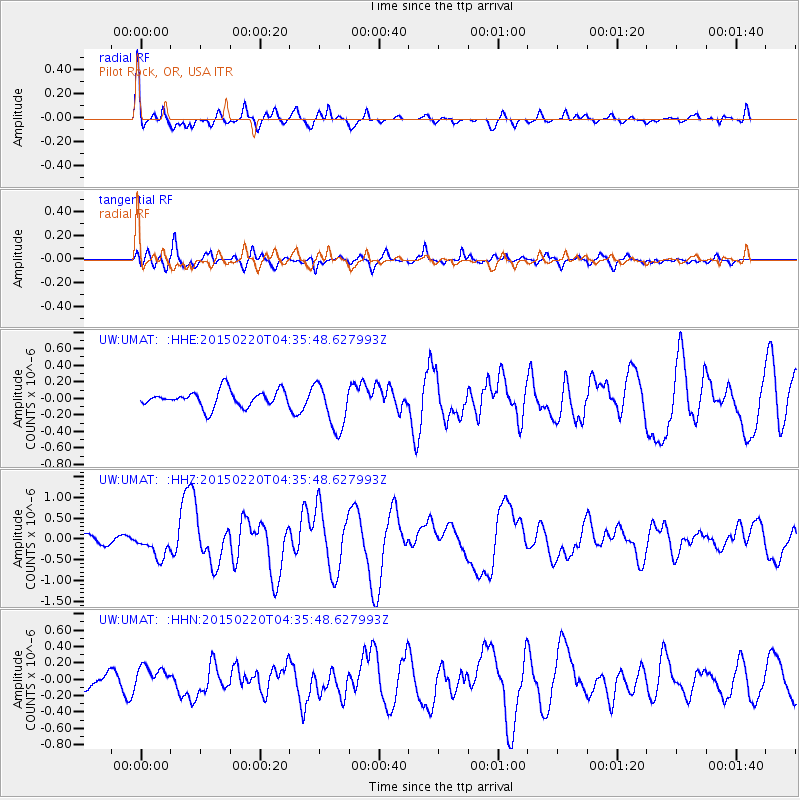
UMAT Pilot Rock, OR, USA - Earthquake Result Viewer
*The percent match for this event was below the threshold and hence no stack was calculated.
| Earthquake location: |
Off East Coast Of Honshu, Japan |
| Earthquake latitude/longitude: |
39.8/143.6 |
| Earthquake time(UTC): |
2015/02/20 (051) 04:25:24 GMT |
| Earthquake Depth: |
14 km |
| Earthquake Magnitude: |
6.3 MWP |
| Earthquake Catalog/Contributor: |
NEIC PDE/NEIC COMCAT |
|
| Network: |
UW Pacific Northwest Regional Seismic Network |
| Station: |
UMAT Pilot Rock, OR, USA |
| Lat/Lon: |
45.29 N/118.96 W |
| Elevation: |
1318 m |
|
| Distance: |
67.6 deg |
| Az: |
49.212 deg |
| Baz: |
304.336 deg |
| Ray Param: |
$rayparam |
*The percent match for this event was below the threshold and hence was not used in the summary stack. |
|
| Radial Match: |
78.025955 % |
| Radial Bump: |
400 |
| Transverse Match: |
64.22151 % |
| Transverse Bump: |
389 |
| SOD ConfigId: |
7019011 |
| Insert Time: |
2019-04-16 23:30:08.386 +0000 |
| GWidth: |
2.5 |
| Max Bumps: |
400 |
| Tol: |
0.001 |
|
Signal To Noise
| Channel | StoN | STA | LTA |
| UW:UMAT: :HHZ:20150220T04:35:48.627993Z | 1.6628736 | 2.9797422E-7 | 1.7919236E-7 |
| UW:UMAT: :HHN:20150220T04:35:48.627993Z | 1.4945252 | 1.3184079E-7 | 8.8215835E-8 |
| UW:UMAT: :HHE:20150220T04:35:48.627993Z | 2.8287652 | 2.8234354E-7 | 9.981159E-8 |
| Arrivals |
| Ps | |
| PpPs | |
| PsPs/PpSs | |


