You are here: Home > Network List > NI - North-East Italy Broadband Network Stations List
> Station ZOU2 Zouf Plan > Earthquake Result Viewer
ZOU2 Zouf Plan - Earthquake Result Viewer
| Earthquake location: |
Guerrero, Mexico |
| Earthquake latitude/longitude: |
17.4/-100.7 |
| Earthquake time(UTC): |
2014/05/08 (128) 17:00:17 GMT |
| Earthquake Depth: |
24 km |
| Earthquake Magnitude: |
6.4 MWW, 6.8 MI |
| Earthquake Catalog/Contributor: |
NEIC PDE/NEIC COMCAT |
|
| Network: |
NI North-East Italy Broadband Network |
| Station: |
ZOU2 Zouf Plan |
| Lat/Lon: |
46.56 N/12.97 E |
| Elevation: |
1896 m |
|
| Distance: |
92.8 deg |
| Az: |
39.269 deg |
| Baz: |
298.85 deg |
| Ray Param: |
0.041376617 |
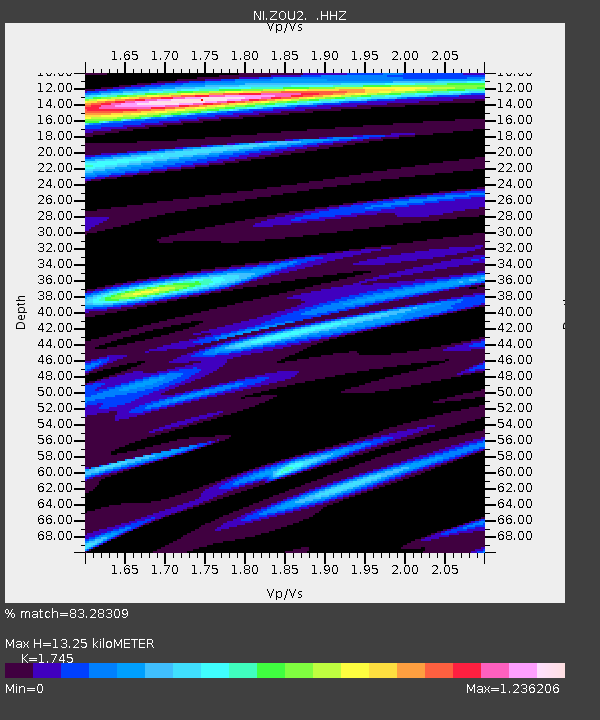
| Estimated Moho Depth: |
13.25 km |
| Estimated Crust Vp/Vs: |
1.75 |
| Assumed Crust Vp: |
6.35 km/s |
| Estimated Crust Vs: |
3.639 km/s |
| Estimated Crust Poisson's Ratio: |
0.26 |
|
| Radial Match: |
83.28309 % |
| Radial Bump: |
395 |
| Transverse Match: |
72.50979 % |
| Transverse Bump: |
386 |
| SOD ConfigId: |
626651 |
| Insert Time: |
2014-05-22 17:33:06.106 +0000 |
| GWidth: |
2.5 |
| Max Bumps: |
400 |
| Tol: |
0.001 |
|

Signal To Noise
| Channel | StoN | STA | LTA |
| NI:ZOU2: :HHZ:20140508T17:12:56.187979Z | 18.8633 | 1.267609E-6 | 6.719975E-8 |
| NI:ZOU2: :HHN:20140508T17:12:56.187979Z | 2.8995662 | 1.708464E-7 | 5.8921366E-8 |
| NI:ZOU2: :HHE:20140508T17:12:56.187979Z | 5.756406 | 3.7648195E-7 | 6.540226E-8 |
| Arrivals |
| Ps | 1.6 SECOND |
| PpPs | 5.6 SECOND |
| PsPs/PpSs | 7.2 SECOND |


