You are here: Home > Network List > PO - Portable Observatories for Lithospheric Analysis and Research Investigating Seis Stations List
> Station CHGQ Chibougamau, QC > Earthquake Result Viewer
CHGQ Chibougamau, QC - Earthquake Result Viewer
| Earthquake location: |
Guerrero, Mexico |
| Earthquake latitude/longitude: |
17.4/-100.7 |
| Earthquake time(UTC): |
2014/05/08 (128) 17:00:17 GMT |
| Earthquake Depth: |
24 km |
| Earthquake Magnitude: |
6.4 MWW, 6.8 MI |
| Earthquake Catalog/Contributor: |
NEIC PDE/NEIC COMCAT |
|
| Network: |
PO Portable Observatories for Lithospheric Analysis and Research Investigating Seis |
| Station: |
CHGQ Chibougamau, QC |
| Lat/Lon: |
49.91 N/74.37 W |
| Elevation: |
406 m |
|
| Distance: |
38.7 deg |
| Az: |
27.228 deg |
| Baz: |
222.514 deg |
| Ray Param: |
0.07535519 |
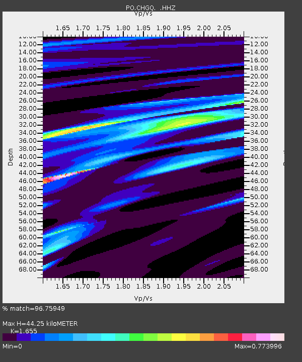
| Estimated Moho Depth: |
44.25 km |
| Estimated Crust Vp/Vs: |
1.65 |
| Assumed Crust Vp: |
6.61 km/s |
| Estimated Crust Vs: |
3.994 km/s |
| Estimated Crust Poisson's Ratio: |
0.21 |
|
| Radial Match: |
96.75949 % |
| Radial Bump: |
145 |
| Transverse Match: |
86.10307 % |
| Transverse Bump: |
347 |
| SOD ConfigId: |
626651 |
| Insert Time: |
2014-05-22 17:34:28.486 +0000 |
| GWidth: |
2.5 |
| Max Bumps: |
400 |
| Tol: |
0.001 |
|

Signal To Noise
| Channel | StoN | STA | LTA |
| PO:CHGQ: :HHZ:20140508T17:07:08.730001Z | 76.56145 | 2.4715655E-6 | 3.2282117E-8 |
| PO:CHGQ: :HHN:20140508T17:07:08.730001Z | 8.3027725 | 8.7415117E-7 | 1.0528425E-7 |
| PO:CHGQ: :HHE:20140508T17:07:08.730001Z | 12.882832 | 1.1542501E-6 | 8.959599E-8 |
| Arrivals |
| Ps | 4.8 SECOND |
| PpPs | 16 SECOND |
| PsPs/PpSs | 21 SECOND |


