You are here: Home > Network List > II - Global Seismograph Network (GSN - IRIS/IDA) Stations List
> Station PFO Pinon Flat, California, USA > Earthquake Result Viewer
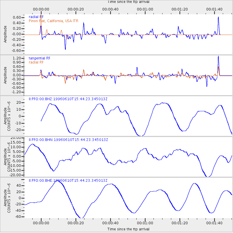
PFO Pinon Flat, California, USA - Earthquake Result Viewer
*The percent match for this event was below the threshold and hence no stack was calculated.
| Earthquake location: |
Andreanof Islands, Aleutian Is. |
| Earthquake latitude/longitude: |
51.2/-176.8 |
| Earthquake time(UTC): |
1996/06/10 (162) 15:36:29 GMT |
| Earthquake Depth: |
33 km |
| Earthquake Magnitude: |
5.5 MB |
| Earthquake Catalog/Contributor: |
WHDF/NEIC |
|
| Network: |
II Global Seismograph Network (GSN - IRIS/IDA) |
| Station: |
PFO Pinon Flat, California, USA |
| Lat/Lon: |
33.61 N/116.46 W |
| Elevation: |
1280 m |
|
| Distance: |
46.5 deg |
| Az: |
87.982 deg |
| Baz: |
311.08 deg |
| Ray Param: |
$rayparam |
*The percent match for this event was below the threshold and hence was not used in the summary stack. |
|
| Radial Match: |
59.866386 % |
| Radial Bump: |
400 |
| Transverse Match: |
45.705498 % |
| Transverse Bump: |
271 |
| SOD ConfigId: |
4480 |
| Insert Time: |
2010-03-01 21:52:56.246 +0000 |
| GWidth: |
2.5 |
| Max Bumps: |
400 |
| Tol: |
0.001 |
|
Signal To Noise
| Channel | StoN | STA | LTA |
| II:PFO:00:BHN:19960610T15:44:23.345013Z | 0.42327982 | 5.4371094E-6 | 1.2845189E-5 |
| II:PFO:00:BHE:19960610T15:44:23.345013Z | 1.5438637 | 1.7385442E-5 | 1.1260995E-5 |
| II:PFO:00:BHZ:19960610T15:44:23.345013Z | 1.1431146 | 1.8175291E-5 | 1.5899797E-5 |
| Arrivals |
| Ps | |
| PpPs | |
| PsPs/PpSs | |


