You are here: Home > Network List > TA - USArray Transportable Network (new EarthScope stations) Stations List
> Station D48A Paudash Township, ON, CAN > Earthquake Result Viewer
D48A Paudash Township, ON, CAN - Earthquake Result Viewer

| Earthquake location: |
Guerrero, Mexico |
| Earthquake latitude/longitude: |
17.4/-100.7 |
| Earthquake time(UTC): |
2014/05/08 (128) 17:00:17 GMT |
| Earthquake Depth: |
24 km |
| Earthquake Magnitude: |
6.4 MWW, 6.8 MI |
| Earthquake Catalog/Contributor: |
NEIC PDE/NEIC COMCAT |
|
| Network: |
TA USArray Transportable Network (new EarthScope stations) |
| Station: |
D48A Paudash Township, ON, CAN |
| Lat/Lon: |
47.17 N/81.81 W |
| Elevation: |
434 m |
|
| Distance: |
33.5 deg |
| Az: |
23.52 deg |
| Baz: |
213.956 deg |
| Ray Param: |
0.07813599 |
| Estimated Moho Depth: |
45.25 km |
| Estimated Crust Vp/Vs: |
1.61 |
| Assumed Crust Vp: |
6.467 km/s |
| Estimated Crust Vs: |
4.01 km/s |
| Estimated Crust Poisson's Ratio: |
0.19 |
|
| Radial Match: |
92.62138 % |
| Radial Bump: |
229 |
| Transverse Match: |
82.48657 % |
| Transverse Bump: |
400 |
| SOD ConfigId: |
626651 |
| Insert Time: |
2014-05-22 17:37:26.925 +0000 |
| GWidth: |
2.5 |
| Max Bumps: |
400 |
| Tol: |
0.001 |
|
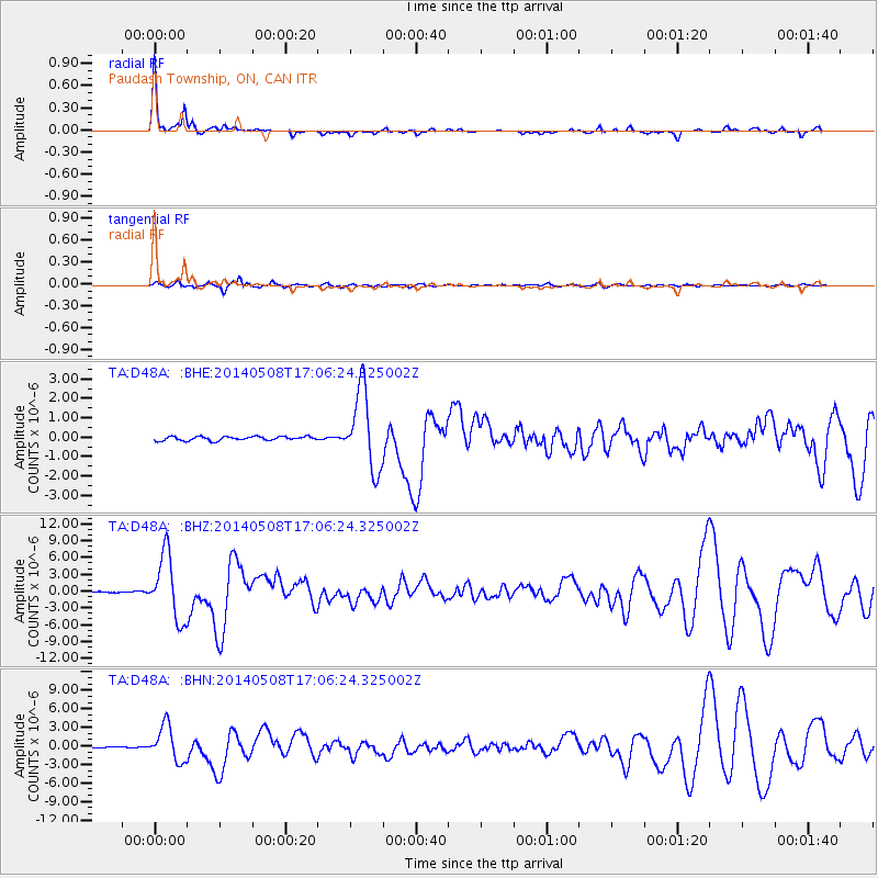
Signal To Noise
| Channel | StoN | STA | LTA |
| TA:D48A: :BHZ:20140508T17:06:24.325002Z | 70.551575 | 5.7172842E-6 | 8.1036944E-8 |
| TA:D48A: :BHN:20140508T17:06:24.325002Z | 41.087254 | 2.8460909E-6 | 6.926943E-8 |
| TA:D48A: :BHE:20140508T17:06:24.325002Z | 19.350592 | 2.0039454E-6 | 1.0355989E-7 |
| Arrivals |
| Ps | 4.7 SECOND |
| PpPs | 17 SECOND |
| PsPs/PpSs | 21 SECOND |


