You are here: Home > Network List > CI - Caltech Regional Seismic Network Stations List
> Station VCS Vincent Substation, Palmdale, CA, USA > Earthquake Result Viewer
VCS Vincent Substation, Palmdale, CA, USA - Earthquake Result Viewer

| Earthquake location: |
Vanuatu Islands |
| Earthquake latitude/longitude: |
-14.9/167.2 |
| Earthquake time(UTC): |
2001/01/09 (009) 16:49:28 GMT |
| Earthquake Depth: |
103 km |
| Earthquake Magnitude: |
6.3 MB, 6.6 MS, 7.6 ME, 7.0 MW |
| Earthquake Catalog/Contributor: |
WHDF/NEIC |
|
| Network: |
CI Caltech Regional Seismic Network |
| Station: |
VCS Vincent Substation, Palmdale, CA, USA |
| Lat/Lon: |
34.48 N/118.12 W |
| Elevation: |
991 m |
|
| Distance: |
86.2 deg |
| Az: |
52.995 deg |
| Baz: |
249.152 deg |
| Ray Param: |
0.04400663 |
| Estimated Moho Depth: |
48.0 km |
| Estimated Crust Vp/Vs: |
1.61 |
| Assumed Crust Vp: |
6.1 km/s |
| Estimated Crust Vs: |
3.801 km/s |
| Estimated Crust Poisson's Ratio: |
0.18 |
|
| Radial Match: |
92.36396 % |
| Radial Bump: |
400 |
| Transverse Match: |
74.04286 % |
| Transverse Bump: |
400 |
| SOD ConfigId: |
3787 |
| Insert Time: |
2010-02-25 21:03:55.018 +0000 |
| GWidth: |
2.5 |
| Max Bumps: |
400 |
| Tol: |
0.001 |
|
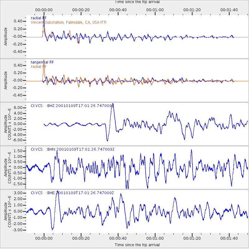
Signal To Noise
| Channel | StoN | STA | LTA |
| CI:VCS: :BHN:20010109T17:01:26.747009Z | 2.405186 | 5.3210647E-7 | 2.21233E-7 |
| CI:VCS: :BHE:20010109T17:01:26.747009Z | 3.8206844 | 1.1755122E-6 | 3.0767058E-7 |
| CI:VCS: :BHZ:20010109T17:01:26.747009Z | 6.603005 | 2.4436729E-6 | 3.7008496E-7 |
| Arrivals |
| Ps | 4.9 SECOND |
| PpPs | 20 SECOND |
| PsPs/PpSs | 25 SECOND |


