You are here: Home > Network List > TA - USArray Transportable Network (new EarthScope stations) Stations List
> Station D63A Stockholm, ME, USA > Earthquake Result Viewer
D63A Stockholm, ME, USA - Earthquake Result Viewer
| Earthquake location: |
Guerrero, Mexico |
| Earthquake latitude/longitude: |
17.4/-100.7 |
| Earthquake time(UTC): |
2014/05/08 (128) 17:00:17 GMT |
| Earthquake Depth: |
24 km |
| Earthquake Magnitude: |
6.4 MWW, 6.8 MI |
| Earthquake Catalog/Contributor: |
NEIC PDE/NEIC COMCAT |
|
| Network: |
TA USArray Transportable Network (new EarthScope stations) |
| Station: |
D63A Stockholm, ME, USA |
| Lat/Lon: |
47.04 N/68.11 W |
| Elevation: |
256 m |
|
| Distance: |
39.9 deg |
| Az: |
35.009 deg |
| Baz: |
233.22 deg |
| Ray Param: |
0.07467293 |
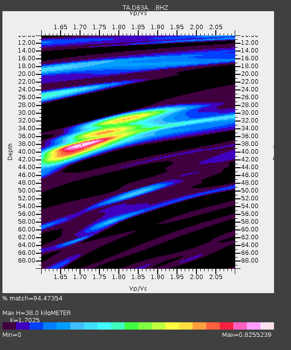
| Estimated Moho Depth: |
38.0 km |
| Estimated Crust Vp/Vs: |
1.70 |
| Assumed Crust Vp: |
6.419 km/s |
| Estimated Crust Vs: |
3.77 km/s |
| Estimated Crust Poisson's Ratio: |
0.24 |
|
| Radial Match: |
94.47354 % |
| Radial Bump: |
331 |
| Transverse Match: |
77.29458 % |
| Transverse Bump: |
400 |
| SOD ConfigId: |
626651 |
| Insert Time: |
2014-05-22 17:38:29.663 +0000 |
| GWidth: |
2.5 |
| Max Bumps: |
400 |
| Tol: |
0.001 |
|
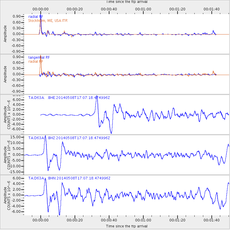
Signal To Noise
| Channel | StoN | STA | LTA |
| TA:D63A: :BHZ:20140508T17:07:18.474996Z | 42.564213 | 7.974888E-6 | 1.8736134E-7 |
| TA:D63A: :BHN:20140508T17:07:18.474996Z | 37.543964 | 3.1650898E-6 | 8.430356E-8 |
| TA:D63A: :BHE:20140508T17:07:18.474996Z | 22.177073 | 3.5914245E-6 | 1.6194312E-7 |
| Arrivals |
| Ps | 4.5 SECOND |
| PpPs | 15 SECOND |
| PsPs/PpSs | 19 SECOND |


