You are here: Home > Network List > TA - USArray Transportable Network (new EarthScope stations) Stations List
> Station E47A Iron Bridge, ON, CAN > Earthquake Result Viewer
E47A Iron Bridge, ON, CAN - Earthquake Result Viewer
| Earthquake location: |
Guerrero, Mexico |
| Earthquake latitude/longitude: |
17.4/-100.7 |
| Earthquake time(UTC): |
2014/05/08 (128) 17:00:17 GMT |
| Earthquake Depth: |
24 km |
| Earthquake Magnitude: |
6.4 MWW, 6.8 MI |
| Earthquake Catalog/Contributor: |
NEIC PDE/NEIC COMCAT |
|
| Network: |
TA USArray Transportable Network (new EarthScope stations) |
| Station: |
E47A Iron Bridge, ON, CAN |
| Lat/Lon: |
46.45 N/83.28 W |
| Elevation: |
246 m |
|
| Distance: |
32.4 deg |
| Az: |
22.686 deg |
| Baz: |
212.188 deg |
| Ray Param: |
0.07865104 |
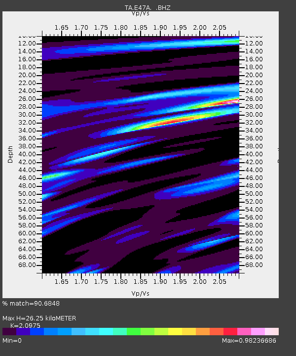
| Estimated Moho Depth: |
26.25 km |
| Estimated Crust Vp/Vs: |
2.10 |
| Assumed Crust Vp: |
6.467 km/s |
| Estimated Crust Vs: |
3.083 km/s |
| Estimated Crust Poisson's Ratio: |
0.35 |
|
| Radial Match: |
90.6848 % |
| Radial Bump: |
255 |
| Transverse Match: |
78.503815 % |
| Transverse Bump: |
400 |
| SOD ConfigId: |
626651 |
| Insert Time: |
2014-05-22 17:38:39.755 +0000 |
| GWidth: |
2.5 |
| Max Bumps: |
400 |
| Tol: |
0.001 |
|

Signal To Noise
| Channel | StoN | STA | LTA |
| TA:E47A: :BHZ:20140508T17:06:14.275015Z | 80.32888 | 6.870349E-6 | 8.552775E-8 |
| TA:E47A: :BHN:20140508T17:06:14.275015Z | 55.653435 | 3.6809229E-6 | 6.614008E-8 |
| TA:E47A: :BHE:20140508T17:06:14.275015Z | 35.251434 | 2.5749707E-6 | 7.304585E-8 |
| Arrivals |
| Ps | 4.8 SECOND |
| PpPs | 12 SECOND |
| PsPs/PpSs | 17 SECOND |


