You are here: Home > Network List > TA - USArray Transportable Network (new EarthScope stations) Stations List
> Station E50A Wahnapitae, ON, CAN > Earthquake Result Viewer
E50A Wahnapitae, ON, CAN - Earthquake Result Viewer
| Earthquake location: |
Guerrero, Mexico |
| Earthquake latitude/longitude: |
17.4/-100.7 |
| Earthquake time(UTC): |
2014/05/08 (128) 17:00:17 GMT |
| Earthquake Depth: |
24 km |
| Earthquake Magnitude: |
6.4 MWW, 6.8 MI |
| Earthquake Catalog/Contributor: |
NEIC PDE/NEIC COMCAT |
|
| Network: |
TA USArray Transportable Network (new EarthScope stations) |
| Station: |
E50A Wahnapitae, ON, CAN |
| Lat/Lon: |
46.42 N/80.74 W |
| Elevation: |
242 m |
|
| Distance: |
33.3 deg |
| Az: |
25.395 deg |
| Baz: |
216.299 deg |
| Ray Param: |
0.078224264 |
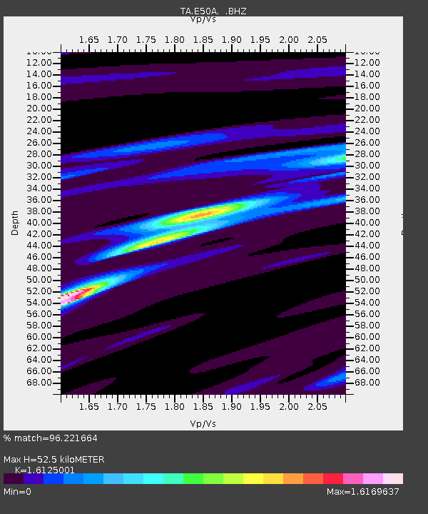
| Estimated Moho Depth: |
52.5 km |
| Estimated Crust Vp/Vs: |
1.61 |
| Assumed Crust Vp: |
6.467 km/s |
| Estimated Crust Vs: |
4.01 km/s |
| Estimated Crust Poisson's Ratio: |
0.19 |
|
| Radial Match: |
96.221664 % |
| Radial Bump: |
152 |
| Transverse Match: |
79.57399 % |
| Transverse Bump: |
400 |
| SOD ConfigId: |
626651 |
| Insert Time: |
2014-05-22 17:38:46.568 +0000 |
| GWidth: |
2.5 |
| Max Bumps: |
400 |
| Tol: |
0.001 |
|

Signal To Noise
| Channel | StoN | STA | LTA |
| TA:E50A: :BHZ:20140508T17:06:22.650015Z | 84.792274 | 5.7067937E-6 | 6.7303226E-8 |
| TA:E50A: :BHN:20140508T17:06:22.650015Z | 51.656284 | 3.8785265E-6 | 7.508334E-8 |
| TA:E50A: :BHE:20140508T17:06:22.650015Z | 30.375422 | 2.0757384E-6 | 6.833612E-8 |
| Arrivals |
| Ps | 5.4 SECOND |
| PpPs | 19 SECOND |
| PsPs/PpSs | 25 SECOND |


