You are here: Home > Network List > TA - USArray Transportable Network (new EarthScope stations) Stations List
> Station G47A Hillman, MI, USA > Earthquake Result Viewer
G47A Hillman, MI, USA - Earthquake Result Viewer

| Earthquake location: |
Guerrero, Mexico |
| Earthquake latitude/longitude: |
17.4/-100.7 |
| Earthquake time(UTC): |
2014/05/08 (128) 17:00:17 GMT |
| Earthquake Depth: |
24 km |
| Earthquake Magnitude: |
6.4 MWW, 6.8 MI |
| Earthquake Catalog/Contributor: |
NEIC PDE/NEIC COMCAT |
|
| Network: |
TA USArray Transportable Network (new EarthScope stations) |
| Station: |
G47A Hillman, MI, USA |
| Lat/Lon: |
45.17 N/83.86 W |
| Elevation: |
239 m |
|
| Distance: |
31.1 deg |
| Az: |
23.338 deg |
| Baz: |
212.329 deg |
| Ray Param: |
0.07914749 |
| Estimated Moho Depth: |
39.0 km |
| Estimated Crust Vp/Vs: |
1.85 |
| Assumed Crust Vp: |
6.483 km/s |
| Estimated Crust Vs: |
3.514 km/s |
| Estimated Crust Poisson's Ratio: |
0.29 |
|
| Radial Match: |
93.17037 % |
| Radial Bump: |
245 |
| Transverse Match: |
72.46994 % |
| Transverse Bump: |
400 |
| SOD ConfigId: |
626651 |
| Insert Time: |
2014-05-22 17:41:14.135 +0000 |
| GWidth: |
2.5 |
| Max Bumps: |
400 |
| Tol: |
0.001 |
|
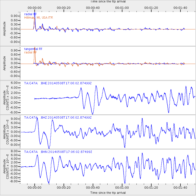
Signal To Noise
| Channel | StoN | STA | LTA |
| TA:G47A: :BHZ:20140508T17:06:02.87499Z | 53.715622 | 5.8544033E-6 | 1.08988836E-7 |
| TA:G47A: :BHN:20140508T17:06:02.87499Z | 41.89681 | 3.7635104E-6 | 8.98281E-8 |
| TA:G47A: :BHE:20140508T17:06:02.87499Z | 16.577583 | 2.6068303E-6 | 1.5725031E-7 |
| Arrivals |
| Ps | 5.5 SECOND |
| PpPs | 16 SECOND |
| PsPs/PpSs | 21 SECOND |


