You are here: Home > Network List > TA - USArray Transportable Network (new EarthScope stations) Stations List
> Station G64A Maxfield, ME, USA > Earthquake Result Viewer
G64A Maxfield, ME, USA - Earthquake Result Viewer
| Earthquake location: |
Guerrero, Mexico |
| Earthquake latitude/longitude: |
17.4/-100.7 |
| Earthquake time(UTC): |
2014/05/08 (128) 17:00:17 GMT |
| Earthquake Depth: |
24 km |
| Earthquake Magnitude: |
6.4 MWW, 6.8 MI |
| Earthquake Catalog/Contributor: |
NEIC PDE/NEIC COMCAT |
|
| Network: |
TA USArray Transportable Network (new EarthScope stations) |
| Station: |
G64A Maxfield, ME, USA |
| Lat/Lon: |
45.25 N/68.76 W |
| Elevation: |
165 m |
|
| Distance: |
38.5 deg |
| Az: |
36.862 deg |
| Baz: |
234.19 deg |
| Ray Param: |
0.075500704 |
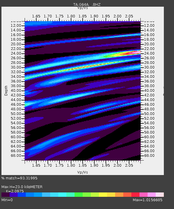
| Estimated Moho Depth: |
23.0 km |
| Estimated Crust Vp/Vs: |
2.10 |
| Assumed Crust Vp: |
6.419 km/s |
| Estimated Crust Vs: |
3.06 km/s |
| Estimated Crust Poisson's Ratio: |
0.35 |
|
| Radial Match: |
93.31995 % |
| Radial Bump: |
236 |
| Transverse Match: |
69.30795 % |
| Transverse Bump: |
400 |
| SOD ConfigId: |
626651 |
| Insert Time: |
2014-05-22 17:41:51.401 +0000 |
| GWidth: |
2.5 |
| Max Bumps: |
400 |
| Tol: |
0.001 |
|

Signal To Noise
| Channel | StoN | STA | LTA |
| TA:G64A: :BHZ:20140508T17:07:06.62499Z | 67.40829 | 7.1751306E-6 | 1.06442855E-7 |
| TA:G64A: :BHN:20140508T17:07:06.62499Z | 29.473534 | 3.4974712E-6 | 1.1866481E-7 |
| TA:G64A: :BHE:20140508T17:07:06.62499Z | 34.76337 | 3.6321044E-6 | 1.0448079E-7 |
| Arrivals |
| Ps | 4.2 SECOND |
| PpPs | 10 SECOND |
| PsPs/PpSs | 15 SECOND |


