You are here: Home > Network List > CI - Caltech Regional Seismic Network Stations List
> Station VCS Vincent Substation, Palmdale, CA, USA > Earthquake Result Viewer
VCS Vincent Substation, Palmdale, CA, USA - Earthquake Result Viewer
| Earthquake location: |
Eastern Honshu, Japan |
| Earthquake latitude/longitude: |
39.4/141.1 |
| Earthquake time(UTC): |
2001/12/02 (336) 13:01:53 GMT |
| Earthquake Depth: |
124 km |
| Earthquake Magnitude: |
6.1 MB, 6.5 MW, 6.5 MW |
| Earthquake Catalog/Contributor: |
WHDF/NEIC |
|
| Network: |
CI Caltech Regional Seismic Network |
| Station: |
VCS Vincent Substation, Palmdale, CA, USA |
| Lat/Lon: |
34.48 N/118.12 W |
| Elevation: |
991 m |
|
| Distance: |
76.3 deg |
| Az: |
56.629 deg |
| Baz: |
308.436 deg |
| Ray Param: |
0.050774124 |
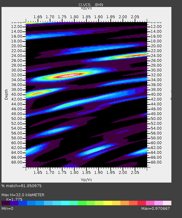
| Estimated Moho Depth: |
32.0 km |
| Estimated Crust Vp/Vs: |
1.77 |
| Assumed Crust Vp: |
6.1 km/s |
| Estimated Crust Vs: |
3.437 km/s |
| Estimated Crust Poisson's Ratio: |
0.27 |
|
| Radial Match: |
91.850975 % |
| Radial Bump: |
400 |
| Transverse Match: |
83.48719 % |
| Transverse Bump: |
400 |
| SOD ConfigId: |
3787 |
| Insert Time: |
2010-02-25 21:03:56.309 +0000 |
| GWidth: |
2.5 |
| Max Bumps: |
400 |
| Tol: |
0.001 |
|
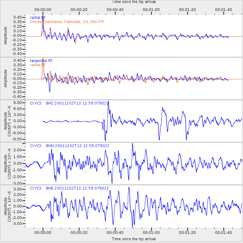
Signal To Noise
| Channel | StoN | STA | LTA |
| CI:VCS: :BHN:20011202T13:12:58.07802Z | 3.2429008 | 7.64456E-7 | 2.3573213E-7 |
| CI:VCS: :BHE:20011202T13:12:58.07802Z | 3.545682 | 7.8933755E-7 | 2.2261938E-7 |
| CI:VCS: :BHZ:20011202T13:12:58.07802Z | 14.88517 | 2.9048508E-6 | 1.9515068E-7 |
| Arrivals |
| Ps | 4.2 SECOND |
| PpPs | 14 SECOND |
| PsPs/PpSs | 18 SECOND |


