You are here: Home > Network List > II - Global Seismograph Network (GSN - IRIS/IDA) Stations List
> Station PFO Pinon Flat, California, USA > Earthquake Result Viewer
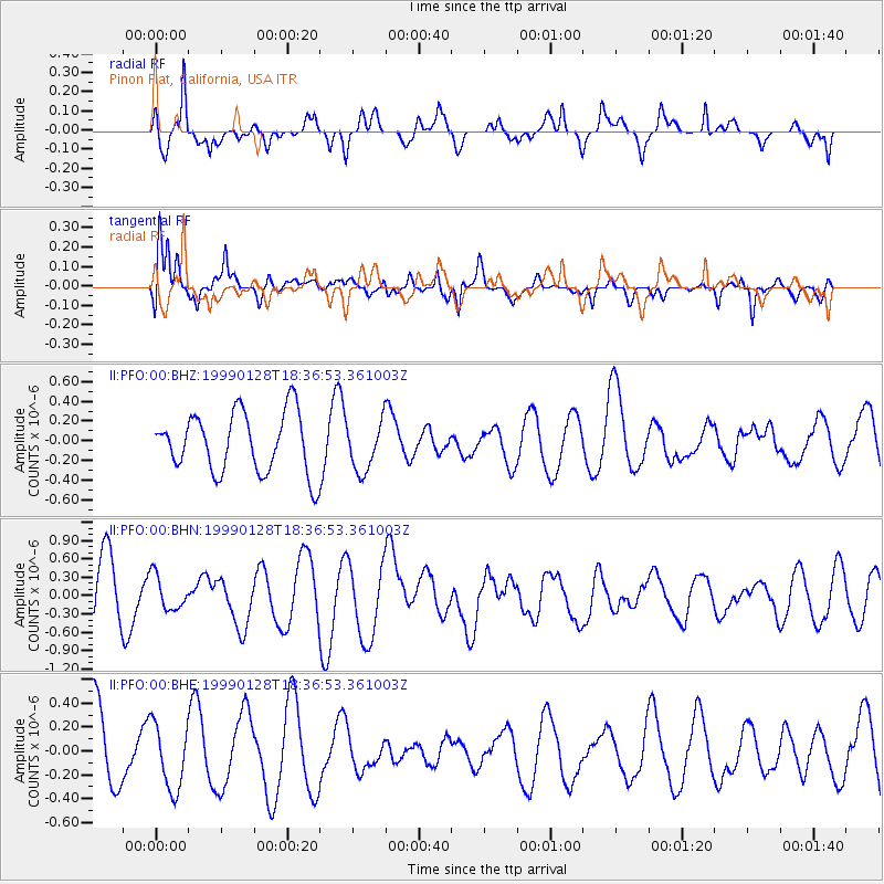
PFO Pinon Flat, California, USA - Earthquake Result Viewer
*The percent match for this event was below the threshold and hence no stack was calculated.
| Earthquake location: |
New Ireland Region, P.N.G. |
| Earthquake latitude/longitude: |
-4.6/153.7 |
| Earthquake time(UTC): |
1999/01/28 (028) 18:24:25 GMT |
| Earthquake Depth: |
101 km |
| Earthquake Magnitude: |
5.6 MB, 6.4 MW, 6.3 MW |
| Earthquake Catalog/Contributor: |
WHDF/NEIC |
|
| Network: |
II Global Seismograph Network (GSN - IRIS/IDA) |
| Station: |
PFO Pinon Flat, California, USA |
| Lat/Lon: |
33.61 N/116.46 W |
| Elevation: |
1280 m |
|
| Distance: |
92.4 deg |
| Az: |
56.645 deg |
| Baz: |
266.137 deg |
| Ray Param: |
$rayparam |
*The percent match for this event was below the threshold and hence was not used in the summary stack. |
|
| Radial Match: |
62.532063 % |
| Radial Bump: |
400 |
| Transverse Match: |
63.450462 % |
| Transverse Bump: |
400 |
| SOD ConfigId: |
4480 |
| Insert Time: |
2010-03-01 21:53:20.967 +0000 |
| GWidth: |
2.5 |
| Max Bumps: |
400 |
| Tol: |
0.001 |
|
Signal To Noise
| Channel | StoN | STA | LTA |
| II:PFO:00:BHN:19990128T18:36:53.361003Z | 0.6064479 | 2.8038698E-7 | 4.6234308E-7 |
| II:PFO:00:BHE:19990128T18:36:53.361003Z | 0.78206855 | 2.7247063E-7 | 3.4839735E-7 |
| II:PFO:00:BHZ:19990128T18:36:53.361003Z | 0.82159406 | 2.5086266E-7 | 3.053365E-7 |
| Arrivals |
| Ps | |
| PpPs | |
| PsPs/PpSs | |


