You are here: Home > Network List > TA - USArray Transportable Network (new EarthScope stations) Stations List
> Station G65A Princeton, ME, USA > Earthquake Result Viewer
G65A Princeton, ME, USA - Earthquake Result Viewer
| Earthquake location: |
Guerrero, Mexico |
| Earthquake latitude/longitude: |
17.4/-100.7 |
| Earthquake time(UTC): |
2014/05/08 (128) 17:00:17 GMT |
| Earthquake Depth: |
24 km |
| Earthquake Magnitude: |
6.4 MWW, 6.8 MI |
| Earthquake Catalog/Contributor: |
NEIC PDE/NEIC COMCAT |
|
| Network: |
TA USArray Transportable Network (new EarthScope stations) |
| Station: |
G65A Princeton, ME, USA |
| Lat/Lon: |
45.20 N/67.56 W |
| Elevation: |
78 m |
|
| Distance: |
39.1 deg |
| Az: |
37.703 deg |
| Baz: |
235.689 deg |
| Ray Param: |
0.07511988 |
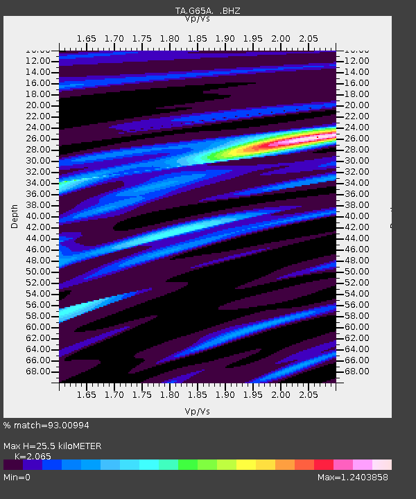
| Estimated Moho Depth: |
25.5 km |
| Estimated Crust Vp/Vs: |
2.07 |
| Assumed Crust Vp: |
6.419 km/s |
| Estimated Crust Vs: |
3.109 km/s |
| Estimated Crust Poisson's Ratio: |
0.35 |
|
| Radial Match: |
93.00994 % |
| Radial Bump: |
240 |
| Transverse Match: |
75.35371 % |
| Transverse Bump: |
400 |
| SOD ConfigId: |
626651 |
| Insert Time: |
2014-05-22 17:41:56.388 +0000 |
| GWidth: |
2.5 |
| Max Bumps: |
400 |
| Tol: |
0.001 |
|
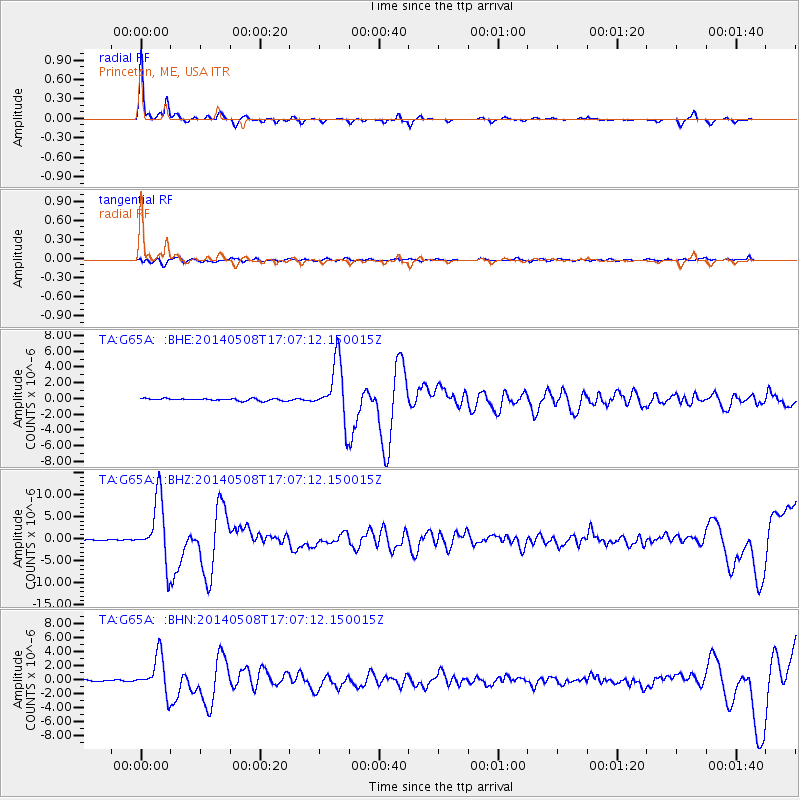
Signal To Noise
| Channel | StoN | STA | LTA |
| TA:G65A: :BHZ:20140508T17:07:12.150015Z | 58.322777 | 7.051586E-6 | 1.2090621E-7 |
| TA:G65A: :BHN:20140508T17:07:12.150015Z | 20.526554 | 2.6130435E-6 | 1.2730064E-7 |
| TA:G65A: :BHE:20140508T17:07:12.150015Z | 26.512283 | 3.6501974E-6 | 1.3767948E-7 |
| Arrivals |
| Ps | 4.5 SECOND |
| PpPs | 11 SECOND |
| PsPs/PpSs | 16 SECOND |


