You are here: Home > Network List > TA - USArray Transportable Network (new EarthScope stations) Stations List
> Station H46A Fife Lake, MI, USA > Earthquake Result Viewer
H46A Fife Lake, MI, USA - Earthquake Result Viewer
| Earthquake location: |
Guerrero, Mexico |
| Earthquake latitude/longitude: |
17.4/-100.7 |
| Earthquake time(UTC): |
2014/05/08 (128) 17:00:17 GMT |
| Earthquake Depth: |
24 km |
| Earthquake Magnitude: |
6.4 MWW, 6.8 MI |
| Earthquake Catalog/Contributor: |
NEIC PDE/NEIC COMCAT |
|
| Network: |
TA USArray Transportable Network (new EarthScope stations) |
| Station: |
H46A Fife Lake, MI, USA |
| Lat/Lon: |
44.54 N/85.20 W |
| Elevation: |
329 m |
|
| Distance: |
30.0 deg |
| Az: |
22.378 deg |
| Baz: |
210.555 deg |
| Ray Param: |
0.07942077 |
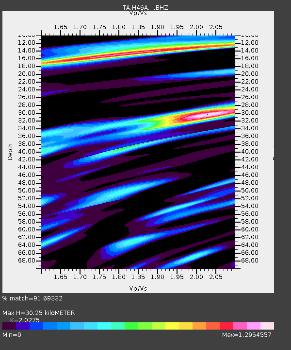
| Estimated Moho Depth: |
30.25 km |
| Estimated Crust Vp/Vs: |
2.03 |
| Assumed Crust Vp: |
6.483 km/s |
| Estimated Crust Vs: |
3.197 km/s |
| Estimated Crust Poisson's Ratio: |
0.34 |
|
| Radial Match: |
91.69332 % |
| Radial Bump: |
400 |
| Transverse Match: |
68.171936 % |
| Transverse Bump: |
400 |
| SOD ConfigId: |
626651 |
| Insert Time: |
2014-05-22 17:42:07.172 +0000 |
| GWidth: |
2.5 |
| Max Bumps: |
400 |
| Tol: |
0.001 |
|

Signal To Noise
| Channel | StoN | STA | LTA |
| TA:H46A: :BHZ:20140508T17:05:53.700002Z | 13.495895 | 7.774194E-6 | 5.760414E-7 |
| TA:H46A: :BHN:20140508T17:05:53.700002Z | 22.011187 | 3.8413687E-6 | 1.7451892E-7 |
| TA:H46A: :BHE:20140508T17:05:53.700002Z | 13.241831 | 2.0978966E-6 | 1.584295E-7 |
| Arrivals |
| Ps | 5.2 SECOND |
| PpPs | 13 SECOND |
| PsPs/PpSs | 18 SECOND |


