You are here: Home > Network List > TA - USArray Transportable Network (new EarthScope stations) Stations List
> Station H61A Lyndonville, VT, USA > Earthquake Result Viewer
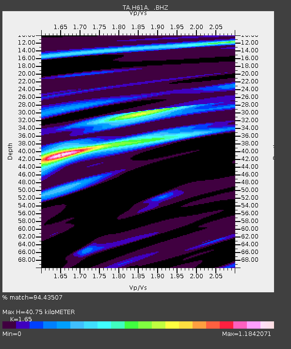
H61A Lyndonville, VT, USA - Earthquake Result Viewer
| Earthquake location: |
Guerrero, Mexico |
| Earthquake latitude/longitude: |
17.4/-100.7 |
| Earthquake time(UTC): |
2014/05/08 (128) 17:00:17 GMT |
| Earthquake Depth: |
24 km |
| Earthquake Magnitude: |
6.4 MWW, 6.8 MI |
| Earthquake Catalog/Contributor: |
NEIC PDE/NEIC COMCAT |
|
| Network: |
TA USArray Transportable Network (new EarthScope stations) |
| Station: |
H61A Lyndonville, VT, USA |
| Lat/Lon: |
44.53 N/71.93 W |
| Elevation: |
462 m |
|
| Distance: |
36.3 deg |
| Az: |
35.544 deg |
| Baz: |
230.911 deg |
| Ray Param: |
0.07674558 |
| Estimated Moho Depth: |
40.75 km |
| Estimated Crust Vp/Vs: |
1.65 |
| Assumed Crust Vp: |
6.419 km/s |
| Estimated Crust Vs: |
3.89 km/s |
| Estimated Crust Poisson's Ratio: |
0.21 |
|
| Radial Match: |
94.43507 % |
| Radial Bump: |
182 |
| Transverse Match: |
79.59344 % |
| Transverse Bump: |
400 |
| SOD ConfigId: |
626651 |
| Insert Time: |
2014-05-22 17:42:49.679 +0000 |
| GWidth: |
2.5 |
| Max Bumps: |
400 |
| Tol: |
0.001 |
|

Signal To Noise
| Channel | StoN | STA | LTA |
| TA:H61A: :BHZ:20140508T17:06:47.800009Z | 34.764397 | 7.0860797E-6 | 2.038315E-7 |
| TA:H61A: :BHN:20140508T17:06:47.800009Z | 31.482735 | 2.5860654E-6 | 8.2142336E-8 |
| TA:H61A: :BHE:20140508T17:06:47.800009Z | 20.899996 | 4.032588E-6 | 1.9294683E-7 |
| Arrivals |
| Ps | 4.5 SECOND |
| PpPs | 16 SECOND |
| PsPs/PpSs | 20 SECOND |


