You are here: Home > Network List > II - Global Seismograph Network (GSN - IRIS/IDA) Stations List
> Station PFO Pinon Flat, California, USA > Earthquake Result Viewer
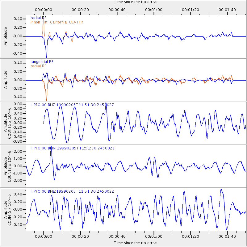
PFO Pinon Flat, California, USA - Earthquake Result Viewer
*The percent match for this event was below the threshold and hence no stack was calculated.
| Earthquake location: |
Santa Cruz Islands |
| Earthquake latitude/longitude: |
-12.6/167.0 |
| Earthquake time(UTC): |
1999/02/05 (036) 11:39:45 GMT |
| Earthquake Depth: |
213 km |
| Earthquake Magnitude: |
5.7 MB, 6.0 MW, 5.9 MW |
| Earthquake Catalog/Contributor: |
WHDF/NEIC |
|
| Network: |
II Global Seismograph Network (GSN - IRIS/IDA) |
| Station: |
PFO Pinon Flat, California, USA |
| Lat/Lon: |
33.61 N/116.46 W |
| Elevation: |
1280 m |
|
| Distance: |
86.0 deg |
| Az: |
54.461 deg |
| Baz: |
252.14 deg |
| Ray Param: |
$rayparam |
*The percent match for this event was below the threshold and hence was not used in the summary stack. |
|
| Radial Match: |
67.377884 % |
| Radial Bump: |
400 |
| Transverse Match: |
65.12977 % |
| Transverse Bump: |
400 |
| SOD ConfigId: |
4480 |
| Insert Time: |
2010-03-01 21:53:32.798 +0000 |
| GWidth: |
2.5 |
| Max Bumps: |
400 |
| Tol: |
0.001 |
|
Signal To Noise
| Channel | StoN | STA | LTA |
| II:PFO:00:BHN:19990205T11:51:30.245002Z | 1.4459565 | 1.0568746E-6 | 7.309173E-7 |
| II:PFO:00:BHE:19990205T11:51:30.245002Z | 0.5866189 | 1.6574513E-7 | 2.8254314E-7 |
| II:PFO:00:BHZ:19990205T11:51:30.245002Z | 0.7956937 | 3.9769986E-7 | 4.9981526E-7 |
| Arrivals |
| Ps | |
| PpPs | |
| PsPs/PpSs | |


