You are here: Home > Network List > TA - USArray Transportable Network (new EarthScope stations) Stations List
> Station I04A Tendick Farm, Oakridge, OR, USA > Earthquake Result Viewer
I04A Tendick Farm, Oakridge, OR, USA - Earthquake Result Viewer
| Earthquake location: |
Guerrero, Mexico |
| Earthquake latitude/longitude: |
17.4/-100.7 |
| Earthquake time(UTC): |
2014/05/08 (128) 17:00:17 GMT |
| Earthquake Depth: |
24 km |
| Earthquake Magnitude: |
6.4 MWW, 6.8 MI |
| Earthquake Catalog/Contributor: |
NEIC PDE/NEIC COMCAT |
|
| Network: |
TA USArray Transportable Network (new EarthScope stations) |
| Station: |
I04A Tendick Farm, Oakridge, OR, USA |
| Lat/Lon: |
43.79 N/122.41 W |
| Elevation: |
731 m |
|
| Distance: |
32.1 deg |
| Az: |
329.673 deg |
| Baz: |
138.254 deg |
| Ray Param: |
0.07876238 |
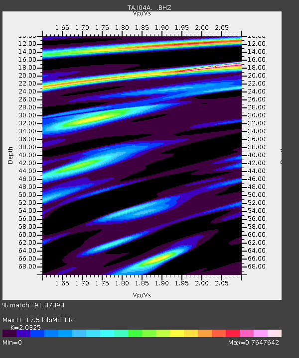
| Estimated Moho Depth: |
17.5 km |
| Estimated Crust Vp/Vs: |
2.03 |
| Assumed Crust Vp: |
6.522 km/s |
| Estimated Crust Vs: |
3.209 km/s |
| Estimated Crust Poisson's Ratio: |
0.34 |
|
| Radial Match: |
91.87898 % |
| Radial Bump: |
262 |
| Transverse Match: |
77.92565 % |
| Transverse Bump: |
400 |
| SOD ConfigId: |
626651 |
| Insert Time: |
2014-05-22 17:43:32.671 +0000 |
| GWidth: |
2.5 |
| Max Bumps: |
400 |
| Tol: |
0.001 |
|
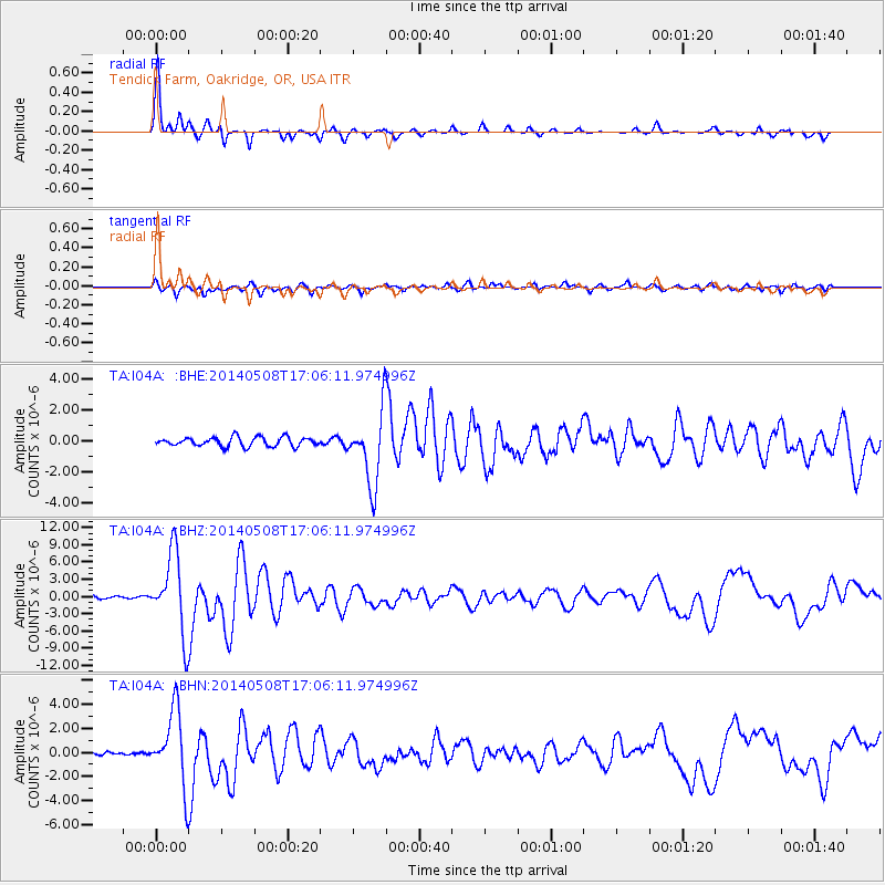
Signal To Noise
| Channel | StoN | STA | LTA |
| TA:I04A: :BHZ:20140508T17:06:11.974996Z | 27.232275 | 6.927538E-6 | 2.5438703E-7 |
| TA:I04A: :BHN:20140508T17:06:11.974996Z | 22.04149 | 3.0504566E-6 | 1.383961E-7 |
| TA:I04A: :BHE:20140508T17:06:11.974996Z | 7.9040265 | 2.3395428E-6 | 2.959938E-7 |
| Arrivals |
| Ps | 3.0 SECOND |
| PpPs | 7.6 SECOND |
| PsPs/PpSs | 11 SECOND |


