You are here: Home > Network List > TA - USArray Transportable Network (new EarthScope stations) Stations List
> Station I48A Sherman Twp, MI, USA > Earthquake Result Viewer
I48A Sherman Twp, MI, USA - Earthquake Result Viewer
| Earthquake location: |
Guerrero, Mexico |
| Earthquake latitude/longitude: |
17.4/-100.7 |
| Earthquake time(UTC): |
2014/05/08 (128) 17:00:17 GMT |
| Earthquake Depth: |
24 km |
| Earthquake Magnitude: |
6.4 MWW, 6.8 MI |
| Earthquake Catalog/Contributor: |
NEIC PDE/NEIC COMCAT |
|
| Network: |
TA USArray Transportable Network (new EarthScope stations) |
| Station: |
I48A Sherman Twp, MI, USA |
| Lat/Lon: |
44.19 N/83.70 W |
| Elevation: |
192 m |
|
| Distance: |
30.3 deg |
| Az: |
24.566 deg |
| Baz: |
213.493 deg |
| Ray Param: |
0.07934925 |
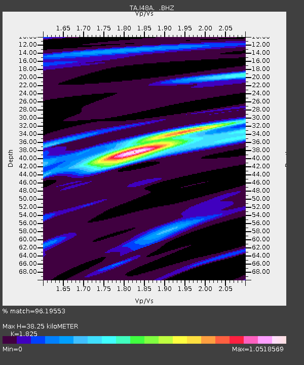
| Estimated Moho Depth: |
38.25 km |
| Estimated Crust Vp/Vs: |
1.83 |
| Assumed Crust Vp: |
6.483 km/s |
| Estimated Crust Vs: |
3.552 km/s |
| Estimated Crust Poisson's Ratio: |
0.29 |
|
| Radial Match: |
96.19553 % |
| Radial Bump: |
199 |
| Transverse Match: |
72.879074 % |
| Transverse Bump: |
400 |
| SOD ConfigId: |
626651 |
| Insert Time: |
2014-05-22 17:43:41.469 +0000 |
| GWidth: |
2.5 |
| Max Bumps: |
400 |
| Tol: |
0.001 |
|

Signal To Noise
| Channel | StoN | STA | LTA |
| TA:I48A: :BHZ:20140508T17:05:56.099996Z | 67.56453 | 9.183045E-6 | 1.3591517E-7 |
| TA:I48A: :BHN:20140508T17:05:56.099996Z | 41.347336 | 4.6619534E-6 | 1.12751E-7 |
| TA:I48A: :BHE:20140508T17:05:56.099996Z | 28.498722 | 3.0372266E-6 | 1.06574134E-7 |
| Arrivals |
| Ps | 5.3 SECOND |
| PpPs | 15 SECOND |
| PsPs/PpSs | 21 SECOND |


