You are here: Home > Network List > TA - USArray Transportable Network (new EarthScope stations) Stations List
> Station P59A Jarrettsville, MD, USA > Earthquake Result Viewer
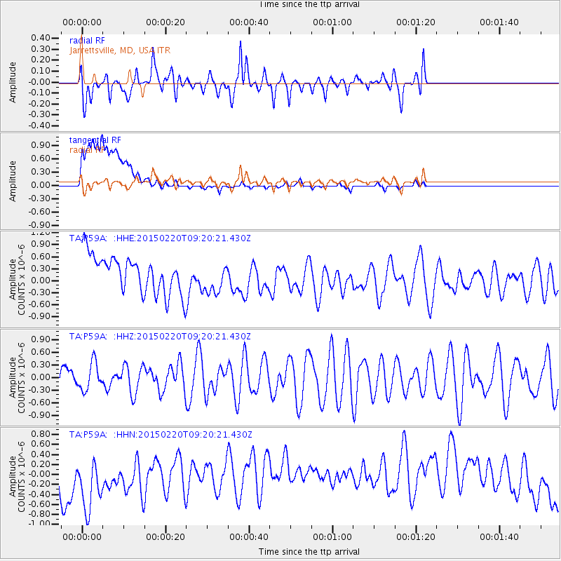
P59A Jarrettsville, MD, USA - Earthquake Result Viewer
*The percent match for this event was below the threshold and hence no stack was calculated.
| Earthquake location: |
Southern Mid-Atlantic Ridge |
| Earthquake latitude/longitude: |
-22.8/-13.3 |
| Earthquake time(UTC): |
2015/02/20 (051) 09:08:14 GMT |
| Earthquake Depth: |
10 km |
| Earthquake Magnitude: |
5.2 MW |
| Earthquake Catalog/Contributor: |
ISC/ISC |
|
| Network: |
TA USArray Transportable Network (new EarthScope stations) |
| Station: |
P59A Jarrettsville, MD, USA |
| Lat/Lon: |
39.61 N/76.43 W |
| Elevation: |
157 m |
|
| Distance: |
85.6 deg |
| Az: |
316.269 deg |
| Baz: |
124.325 deg |
| Ray Param: |
$rayparam |
*The percent match for this event was below the threshold and hence was not used in the summary stack. |
|
| Radial Match: |
66.726585 % |
| Radial Bump: |
400 |
| Transverse Match: |
41.085236 % |
| Transverse Bump: |
400 |
| SOD ConfigId: |
7019011 |
| Insert Time: |
2019-04-16 23:37:33.154 +0000 |
| GWidth: |
2.5 |
| Max Bumps: |
400 |
| Tol: |
0.001 |
|
Signal To Noise
| Channel | StoN | STA | LTA |
| TA:P59A: :HHZ:20150220T09:20:21.430Z | 0.91229063 | 3.296048E-7 | 3.6129364E-7 |
| TA:P59A: :HHN:20150220T09:20:21.430Z | 1.4401443 | 7.9955345E-7 | 5.551898E-7 |
| TA:P59A: :HHE:20150220T09:20:21.430Z | 0.8864385 | 4.0470096E-7 | 4.5654713E-7 |
| Arrivals |
| Ps | |
| PpPs | |
| PsPs/PpSs | |


