You are here: Home > Network List > TA - USArray Transportable Network (new EarthScope stations) Stations List
> Station I57A Carthage, NY, USA > Earthquake Result Viewer
I57A Carthage, NY, USA - Earthquake Result Viewer
| Earthquake location: |
Guerrero, Mexico |
| Earthquake latitude/longitude: |
17.4/-100.7 |
| Earthquake time(UTC): |
2014/05/08 (128) 17:00:17 GMT |
| Earthquake Depth: |
24 km |
| Earthquake Magnitude: |
6.4 MWW, 6.8 MI |
| Earthquake Catalog/Contributor: |
NEIC PDE/NEIC COMCAT |
|
| Network: |
TA USArray Transportable Network (new EarthScope stations) |
| Station: |
I57A Carthage, NY, USA |
| Lat/Lon: |
43.94 N/75.66 W |
| Elevation: |
321 m |
|
| Distance: |
33.8 deg |
| Az: |
33.238 deg |
| Baz: |
226.427 deg |
| Ray Param: |
0.07798949 |
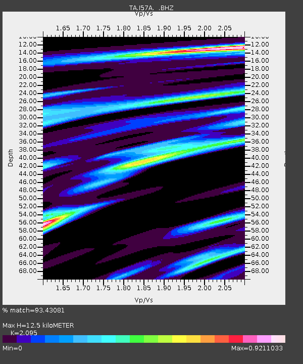
| Estimated Moho Depth: |
12.5 km |
| Estimated Crust Vp/Vs: |
2.10 |
| Assumed Crust Vp: |
6.419 km/s |
| Estimated Crust Vs: |
3.064 km/s |
| Estimated Crust Poisson's Ratio: |
0.35 |
|
| Radial Match: |
93.43081 % |
| Radial Bump: |
224 |
| Transverse Match: |
57.03551 % |
| Transverse Bump: |
400 |
| SOD ConfigId: |
626651 |
| Insert Time: |
2014-05-22 17:44:06.277 +0000 |
| GWidth: |
2.5 |
| Max Bumps: |
400 |
| Tol: |
0.001 |
|

Signal To Noise
| Channel | StoN | STA | LTA |
| TA:I57A: :BHZ:20140508T17:06:27.099996Z | 54.44722 | 4.9930172E-6 | 9.1703804E-8 |
| TA:I57A: :BHN:20140508T17:06:27.099996Z | 21.938896 | 2.031032E-6 | 9.257676E-8 |
| TA:I57A: :BHE:20140508T17:06:27.099996Z | 18.254593 | 2.295572E-6 | 1.2575312E-7 |
| Arrivals |
| Ps | 2.3 SECOND |
| PpPs | 5.6 SECOND |
| PsPs/PpSs | 7.9 SECOND |


