You are here: Home > Network List > TA - USArray Transportable Network (new EarthScope stations) Stations List
> Station I59A Olmsteadville, NY, USA > Earthquake Result Viewer
I59A Olmsteadville, NY, USA - Earthquake Result Viewer

| Earthquake location: |
Guerrero, Mexico |
| Earthquake latitude/longitude: |
17.4/-100.7 |
| Earthquake time(UTC): |
2014/05/08 (128) 17:00:17 GMT |
| Earthquake Depth: |
24 km |
| Earthquake Magnitude: |
6.4 MWW, 6.8 MI |
| Earthquake Catalog/Contributor: |
NEIC PDE/NEIC COMCAT |
|
| Network: |
TA USArray Transportable Network (new EarthScope stations) |
| Station: |
I59A Olmsteadville, NY, USA |
| Lat/Lon: |
43.80 N/73.87 W |
| Elevation: |
390 m |
|
| Distance: |
34.7 deg |
| Az: |
34.966 deg |
| Baz: |
229.088 deg |
| Ray Param: |
0.0775691 |
| Estimated Moho Depth: |
13.75 km |
| Estimated Crust Vp/Vs: |
2.10 |
| Assumed Crust Vp: |
6.419 km/s |
| Estimated Crust Vs: |
3.06 km/s |
| Estimated Crust Poisson's Ratio: |
0.35 |
|
| Radial Match: |
92.49333 % |
| Radial Bump: |
271 |
| Transverse Match: |
61.042465 % |
| Transverse Bump: |
400 |
| SOD ConfigId: |
626651 |
| Insert Time: |
2014-05-22 17:44:18.199 +0000 |
| GWidth: |
2.5 |
| Max Bumps: |
400 |
| Tol: |
0.001 |
|
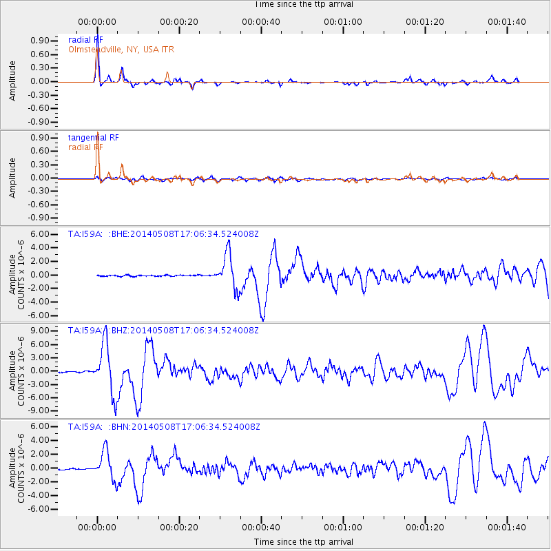
Signal To Noise
| Channel | StoN | STA | LTA |
| TA:I59A: :BHZ:20140508T17:06:34.524008Z | 74.92981 | 5.8778774E-6 | 7.844512E-8 |
| TA:I59A: :BHN:20140508T17:06:34.524008Z | 33.295433 | 2.1269716E-6 | 6.388178E-8 |
| TA:I59A: :BHE:20140508T17:06:34.524008Z | 34.3441 | 2.647183E-6 | 7.707824E-8 |
| Arrivals |
| Ps | 2.5 SECOND |
| PpPs | 6.2 SECOND |
| PsPs/PpSs | 8.7 SECOND |


