You are here: Home > Network List > TA - USArray Transportable Network (new EarthScope stations) Stations List
> Station I62A Tamworth, NH, USA > Earthquake Result Viewer
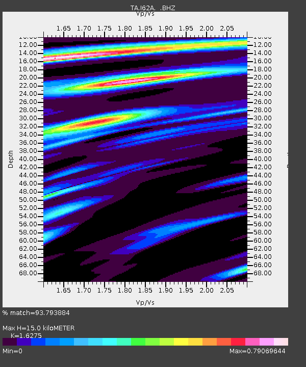
I62A Tamworth, NH, USA - Earthquake Result Viewer
| Earthquake location: |
Guerrero, Mexico |
| Earthquake latitude/longitude: |
17.4/-100.7 |
| Earthquake time(UTC): |
2014/05/08 (128) 17:00:17 GMT |
| Earthquake Depth: |
24 km |
| Earthquake Magnitude: |
6.4 MWW, 6.8 MI |
| Earthquake Catalog/Contributor: |
NEIC PDE/NEIC COMCAT |
|
| Network: |
TA USArray Transportable Network (new EarthScope stations) |
| Station: |
I62A Tamworth, NH, USA |
| Lat/Lon: |
43.87 N/71.34 W |
| Elevation: |
264 m |
|
| Distance: |
36.2 deg |
| Az: |
36.866 deg |
| Baz: |
232.388 deg |
| Ray Param: |
0.07678681 |
| Estimated Moho Depth: |
15.0 km |
| Estimated Crust Vp/Vs: |
1.63 |
| Assumed Crust Vp: |
6.419 km/s |
| Estimated Crust Vs: |
3.944 km/s |
| Estimated Crust Poisson's Ratio: |
0.20 |
|
| Radial Match: |
93.793884 % |
| Radial Bump: |
277 |
| Transverse Match: |
86.580185 % |
| Transverse Bump: |
400 |
| SOD ConfigId: |
626651 |
| Insert Time: |
2014-05-22 17:44:31.470 +0000 |
| GWidth: |
2.5 |
| Max Bumps: |
400 |
| Tol: |
0.001 |
|

Signal To Noise
| Channel | StoN | STA | LTA |
| TA:I62A: :BHZ:20140508T17:06:47.150015Z | 63.5912 | 8.014464E-6 | 1.2603101E-7 |
| TA:I62A: :BHN:20140508T17:06:47.150015Z | 26.013994 | 2.9639193E-6 | 1.1393558E-7 |
| TA:I62A: :BHE:20140508T17:06:47.150015Z | 45.73125 | 3.854982E-6 | 8.4296445E-8 |
| Arrivals |
| Ps | 1.6 SECOND |
| PpPs | 5.7 SECOND |
| PsPs/PpSs | 7.2 SECOND |


