You are here: Home > Network List > TA - USArray Transportable Network (new EarthScope stations) Stations List
> Station M58A Price's Panorama, Nuncy Valley, PA, USA > Earthquake Result Viewer
M58A Price's Panorama, Nuncy Valley, PA, USA - Earthquake Result Viewer
| Earthquake location: |
Guerrero, Mexico |
| Earthquake latitude/longitude: |
17.4/-100.7 |
| Earthquake time(UTC): |
2014/05/08 (128) 17:00:17 GMT |
| Earthquake Depth: |
24 km |
| Earthquake Magnitude: |
6.4 MWW, 6.8 MI |
| Earthquake Catalog/Contributor: |
NEIC PDE/NEIC COMCAT |
|
| Network: |
TA USArray Transportable Network (new EarthScope stations) |
| Station: |
M58A Price's Panorama, Nuncy Valley, PA, USA |
| Lat/Lon: |
41.37 N/76.46 W |
| Elevation: |
529 m |
|
| Distance: |
31.7 deg |
| Az: |
35.981 deg |
| Baz: |
228.194 deg |
| Ray Param: |
0.078948766 |
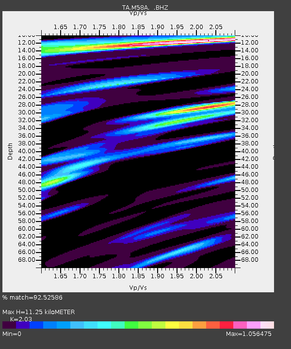
| Estimated Moho Depth: |
11.25 km |
| Estimated Crust Vp/Vs: |
2.03 |
| Assumed Crust Vp: |
6.121 km/s |
| Estimated Crust Vs: |
3.015 km/s |
| Estimated Crust Poisson's Ratio: |
0.34 |
|
| Radial Match: |
92.52586 % |
| Radial Bump: |
400 |
| Transverse Match: |
73.339035 % |
| Transverse Bump: |
400 |
| SOD ConfigId: |
626651 |
| Insert Time: |
2014-05-22 17:48:46.830 +0000 |
| GWidth: |
2.5 |
| Max Bumps: |
400 |
| Tol: |
0.001 |
|

Signal To Noise
| Channel | StoN | STA | LTA |
| TA:M58A: :BHZ:20140508T17:06:08.150015Z | 50.339794 | 6.911504E-6 | 1.3729702E-7 |
| TA:M58A: :BHN:20140508T17:06:08.150015Z | 7.186297 | 2.4016208E-6 | 3.3419445E-7 |
| TA:M58A: :BHE:20140508T17:06:08.150015Z | 31.001778 | 2.814503E-6 | 9.078521E-8 |
| Arrivals |
| Ps | 2.0 SECOND |
| PpPs | 5.2 SECOND |
| PsPs/PpSs | 7.2 SECOND |


