You are here: Home > Network List > II - Global Seismograph Network (GSN - IRIS/IDA) Stations List
> Station PFO Pinon Flat, California, USA > Earthquake Result Viewer
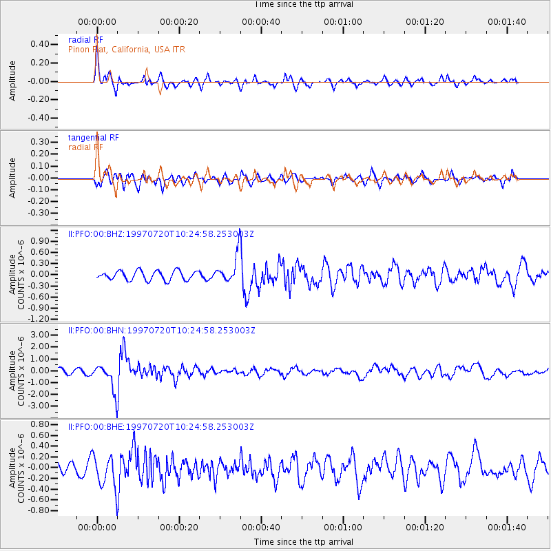
PFO Pinon Flat, California, USA - Earthquake Result Viewer
*The percent match for this event was below the threshold and hence no stack was calculated.
| Earthquake location: |
Jujuy Province, Argentina |
| Earthquake latitude/longitude: |
-23.0/-66.3 |
| Earthquake time(UTC): |
1997/07/20 (201) 10:14:22 GMT |
| Earthquake Depth: |
256 km |
| Earthquake Magnitude: |
5.7 MB, 6.1 UNKNOWN, 5.7 ME |
| Earthquake Catalog/Contributor: |
WHDF/NEIC |
|
| Network: |
II Global Seismograph Network (GSN - IRIS/IDA) |
| Station: |
PFO Pinon Flat, California, USA |
| Lat/Lon: |
33.61 N/116.46 W |
| Elevation: |
1280 m |
|
| Distance: |
73.8 deg |
| Az: |
318.148 deg |
| Baz: |
132.542 deg |
| Ray Param: |
$rayparam |
*The percent match for this event was below the threshold and hence was not used in the summary stack. |
|
| Radial Match: |
78.326996 % |
| Radial Bump: |
400 |
| Transverse Match: |
67.48323 % |
| Transverse Bump: |
400 |
| SOD ConfigId: |
4480 |
| Insert Time: |
2010-03-01 21:53:58.129 +0000 |
| GWidth: |
2.5 |
| Max Bumps: |
400 |
| Tol: |
0.001 |
|
Signal To Noise
| Channel | StoN | STA | LTA |
| II:PFO:00:BHN:19970720T10:24:58.253003Z | 5.6640177 | 1.188715E-6 | 2.0987135E-7 |
| II:PFO:00:BHE:19970720T10:24:58.253003Z | 3.1058023 | 2.969764E-7 | 9.561987E-8 |
| II:PFO:00:BHZ:19970720T10:24:58.253003Z | 3.2474833 | 4.0016153E-7 | 1.2322205E-7 |
| Arrivals |
| Ps | |
| PpPs | |
| PsPs/PpSs | |


