You are here: Home > Network List > II - Global Seismograph Network (GSN - IRIS/IDA) Stations List
> Station PFO Pinon Flat, California, USA > Earthquake Result Viewer
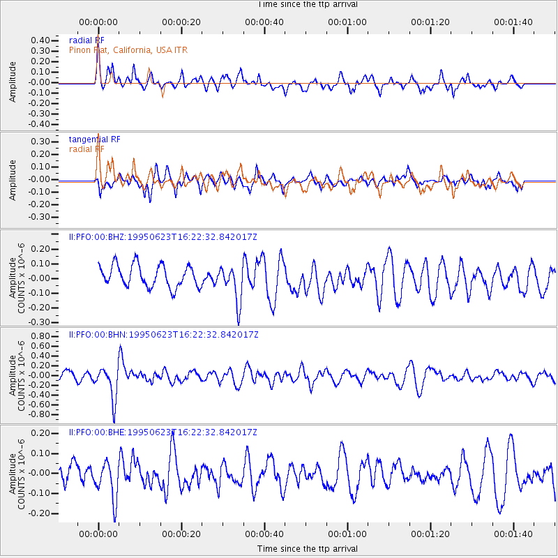
PFO Pinon Flat, California, USA - Earthquake Result Viewer
*The percent match for this event was below the threshold and hence no stack was calculated.
| Earthquake location: |
South Of Fiji Islands |
| Earthquake latitude/longitude: |
-24.6/-177.3 |
| Earthquake time(UTC): |
1995/06/23 (174) 16:10:56 GMT |
| Earthquake Depth: |
108 km |
| Earthquake Magnitude: |
5.8 UNKNOWN, 5.4 MB |
| Earthquake Catalog/Contributor: |
WHDF/NEIC |
|
| Network: |
II Global Seismograph Network (GSN - IRIS/IDA) |
| Station: |
PFO Pinon Flat, California, USA |
| Lat/Lon: |
33.61 N/116.46 W |
| Elevation: |
1280 m |
|
| Distance: |
81.8 deg |
| Az: |
47.407 deg |
| Baz: |
233.432 deg |
| Ray Param: |
$rayparam |
*The percent match for this event was below the threshold and hence was not used in the summary stack. |
|
| Radial Match: |
67.11628 % |
| Radial Bump: |
400 |
| Transverse Match: |
55.400856 % |
| Transverse Bump: |
400 |
| SOD ConfigId: |
4480 |
| Insert Time: |
2010-03-01 21:54:15.816 +0000 |
| GWidth: |
2.5 |
| Max Bumps: |
400 |
| Tol: |
0.001 |
|
Signal To Noise
| Channel | StoN | STA | LTA |
| II:PFO:00:BHN:19950623T16:22:32.842017Z | 3.1048746 | 3.3912744E-7 | 1.092242E-7 |
| II:PFO:00:BHE:19950623T16:22:32.842017Z | 2.1525867 | 9.6113375E-8 | 4.4650175E-8 |
| II:PFO:00:BHZ:19950623T16:22:32.842017Z | 1.7332156 | 1.2830958E-7 | 7.4029785E-8 |
| Arrivals |
| Ps | |
| PpPs | |
| PsPs/PpSs | |


