You are here: Home > Network List > US - United States National Seismic Network Stations List
> Station COWI Conover, Wisconsin, USA > Earthquake Result Viewer
COWI Conover, Wisconsin, USA - Earthquake Result Viewer
| Earthquake location: |
Guerrero, Mexico |
| Earthquake latitude/longitude: |
17.4/-100.7 |
| Earthquake time(UTC): |
2014/05/08 (128) 17:00:17 GMT |
| Earthquake Depth: |
24 km |
| Earthquake Magnitude: |
6.4 MWW, 6.8 MI |
| Earthquake Catalog/Contributor: |
NEIC PDE/NEIC COMCAT |
|
| Network: |
US United States National Seismic Network |
| Station: |
COWI Conover, Wisconsin, USA |
| Lat/Lon: |
46.10 N/89.14 W |
| Elevation: |
523 m |
|
| Distance: |
30.2 deg |
| Az: |
16.039 deg |
| Baz: |
202.282 deg |
| Ray Param: |
0.07937807 |
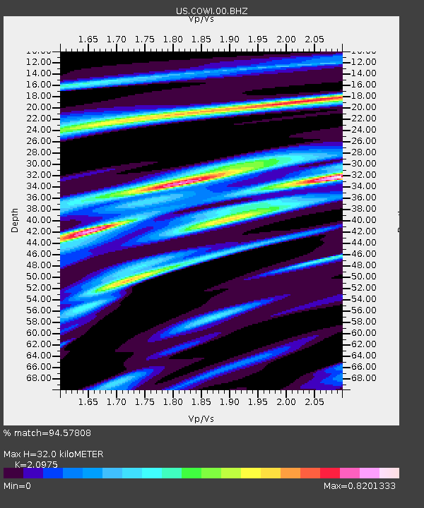
| Estimated Moho Depth: |
32.0 km |
| Estimated Crust Vp/Vs: |
2.10 |
| Assumed Crust Vp: |
6.467 km/s |
| Estimated Crust Vs: |
3.083 km/s |
| Estimated Crust Poisson's Ratio: |
0.35 |
|
| Radial Match: |
94.57808 % |
| Radial Bump: |
250 |
| Transverse Match: |
79.11602 % |
| Transverse Bump: |
400 |
| SOD ConfigId: |
626651 |
| Insert Time: |
2014-05-22 17:51:27.130 +0000 |
| GWidth: |
2.5 |
| Max Bumps: |
400 |
| Tol: |
0.001 |
|

Signal To Noise
| Channel | StoN | STA | LTA |
| US:COWI:00:BHZ:20140508T17:05:55.12499Z | 74.66931 | 5.8505934E-6 | 7.835338E-8 |
| US:COWI:00:BH1:20140508T17:05:55.12499Z | 36.562325 | 3.8124358E-6 | 1.04272246E-7 |
| US:COWI:00:BH2:20140508T17:05:55.12499Z | 24.448235 | 1.2165218E-6 | 4.9759088E-8 |
| Arrivals |
| Ps | 5.8 SECOND |
| PpPs | 14 SECOND |
| PsPs/PpSs | 20 SECOND |


