You are here: Home > Network List > UW - Pacific Northwest Regional Seismic Network Stations List
> Station MRBL Marblemount, WA, USA > Earthquake Result Viewer
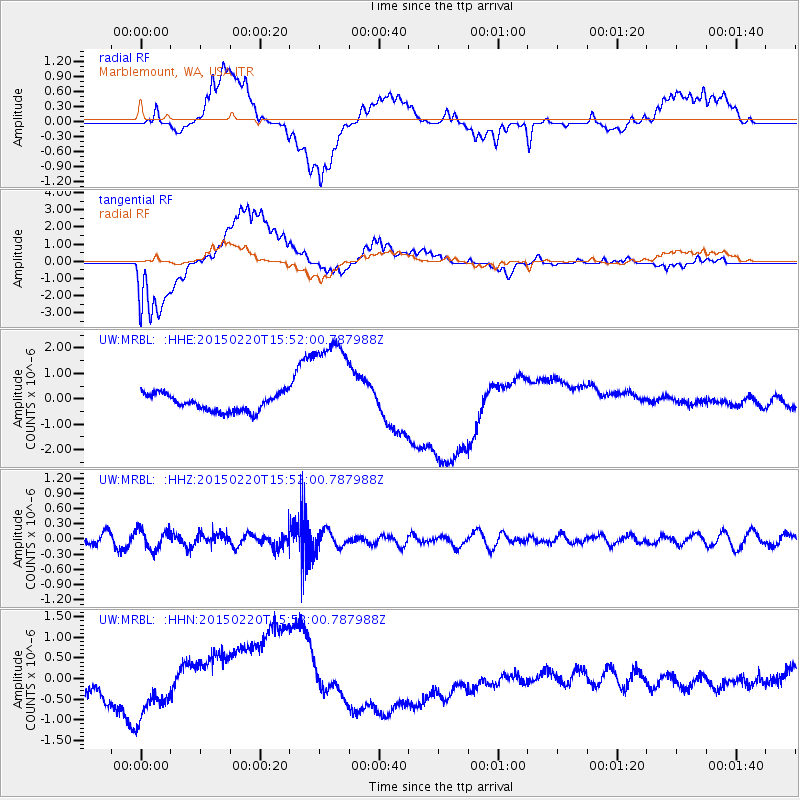
MRBL Marblemount, WA, USA - Earthquake Result Viewer
*The percent match for this event was below the threshold and hence no stack was calculated.
| Earthquake location: |
Kermadec Islands Region |
| Earthquake latitude/longitude: |
-31.2/-178.2 |
| Earthquake time(UTC): |
2015/02/20 (051) 15:39:17 GMT |
| Earthquake Depth: |
35 km |
| Earthquake Magnitude: |
5.1 MW |
| Earthquake Catalog/Contributor: |
ISC/ISC |
|
| Network: |
UW Pacific Northwest Regional Seismic Network |
| Station: |
MRBL Marblemount, WA, USA |
| Lat/Lon: |
48.52 N/121.48 W |
| Elevation: |
75 m |
|
| Distance: |
94.1 deg |
| Az: |
33.888 deg |
| Baz: |
225.966 deg |
| Ray Param: |
$rayparam |
*The percent match for this event was below the threshold and hence was not used in the summary stack. |
|
| Radial Match: |
20.261045 % |
| Radial Bump: |
400 |
| Transverse Match: |
18.57284 % |
| Transverse Bump: |
400 |
| SOD ConfigId: |
7019011 |
| Insert Time: |
2019-04-16 23:44:17.616 +0000 |
| GWidth: |
2.5 |
| Max Bumps: |
400 |
| Tol: |
0.001 |
|
Signal To Noise
| Channel | StoN | STA | LTA |
| UW:MRBL: :HHZ:20150220T15:52:00.787988Z | 1.8794142 | 2.0127843E-7 | 1.0709636E-7 |
| UW:MRBL: :HHN:20150220T15:52:00.787988Z | 1.5951225 | 4.8625884E-7 | 3.0484108E-7 |
| UW:MRBL: :HHE:20150220T15:52:00.787988Z | 6.240554 | 2.0752834E-6 | 3.3254796E-7 |
| Arrivals |
| Ps | |
| PpPs | |
| PsPs/PpSs | |


