You are here: Home > Network List > US - United States National Seismic Network Stations List
> Station WRAK Wrangell Island, Southeastern Alaska, Alaska, USA > Earthquake Result Viewer
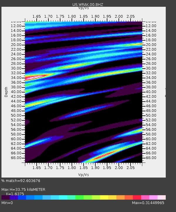
WRAK Wrangell Island, Southeastern Alaska, Alaska, USA - Earthquake Result Viewer
| Earthquake location: |
Guerrero, Mexico |
| Earthquake latitude/longitude: |
17.4/-100.7 |
| Earthquake time(UTC): |
2014/05/08 (128) 17:00:17 GMT |
| Earthquake Depth: |
24 km |
| Earthquake Magnitude: |
6.4 MWW, 6.8 MI |
| Earthquake Catalog/Contributor: |
NEIC PDE/NEIC COMCAT |
|
| Network: |
US United States National Seismic Network |
| Station: |
WRAK Wrangell Island, Southeastern Alaska, Alaska, USA |
| Lat/Lon: |
56.42 N/132.35 W |
| Elevation: |
81 m |
|
| Distance: |
45.7 deg |
| Az: |
335.928 deg |
| Baz: |
135.502 deg |
| Ray Param: |
0.07106493 |
| Estimated Moho Depth: |
33.75 km |
| Estimated Crust Vp/Vs: |
1.64 |
| Assumed Crust Vp: |
6.597 km/s |
| Estimated Crust Vs: |
4.029 km/s |
| Estimated Crust Poisson's Ratio: |
0.20 |
|
| Radial Match: |
92.603676 % |
| Radial Bump: |
206 |
| Transverse Match: |
80.568474 % |
| Transverse Bump: |
400 |
| SOD ConfigId: |
626651 |
| Insert Time: |
2014-05-22 17:52:20.308 +0000 |
| GWidth: |
2.5 |
| Max Bumps: |
400 |
| Tol: |
0.001 |
|

Signal To Noise
| Channel | StoN | STA | LTA |
| US:WRAK:00:BHZ:20140508T17:08:05.425009Z | 32.02488 | 4.6917794E-6 | 1.465042E-7 |
| US:WRAK:00:BH1:20140508T17:08:05.425009Z | 19.241337 | 2.0735504E-6 | 1.077654E-7 |
| US:WRAK:00:BH2:20140508T17:08:05.425009Z | 9.96924 | 1.6899243E-6 | 1.6951385E-7 |
| Arrivals |
| Ps | 3.5 SECOND |
| PpPs | 13 SECOND |
| PsPs/PpSs | 16 SECOND |


