You are here: Home > Network List > UW - Pacific Northwest Regional Seismic Network Stations List
> Station LEBA Lebam, WA, USA > Earthquake Result Viewer
LEBA Lebam, WA, USA - Earthquake Result Viewer
| Earthquake location: |
Guerrero, Mexico |
| Earthquake latitude/longitude: |
17.4/-100.7 |
| Earthquake time(UTC): |
2014/05/08 (128) 17:00:17 GMT |
| Earthquake Depth: |
24 km |
| Earthquake Magnitude: |
6.4 MWW, 6.8 MI |
| Earthquake Catalog/Contributor: |
NEIC PDE/NEIC COMCAT |
|
| Network: |
UW Pacific Northwest Regional Seismic Network |
| Station: |
LEBA Lebam, WA, USA |
| Lat/Lon: |
46.55 N/123.56 W |
| Elevation: |
73 m |
|
| Distance: |
34.7 deg |
| Az: |
331.854 deg |
| Baz: |
139.261 deg |
| Ray Param: |
0.07756319 |
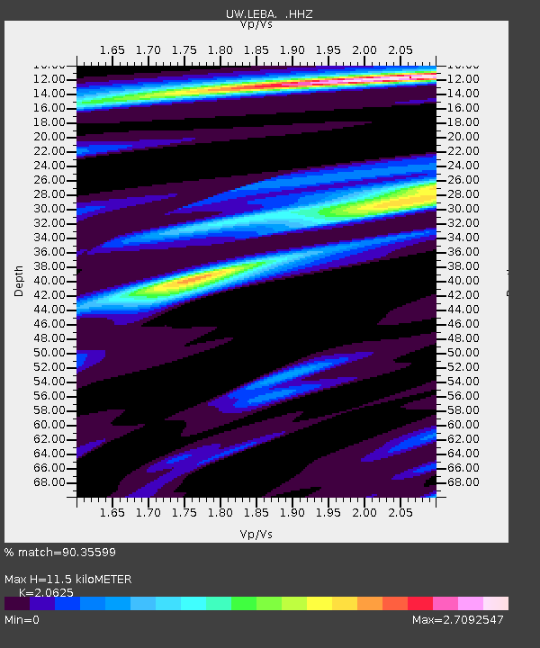
| Estimated Moho Depth: |
11.5 km |
| Estimated Crust Vp/Vs: |
2.06 |
| Assumed Crust Vp: |
6.566 km/s |
| Estimated Crust Vs: |
3.184 km/s |
| Estimated Crust Poisson's Ratio: |
0.35 |
|
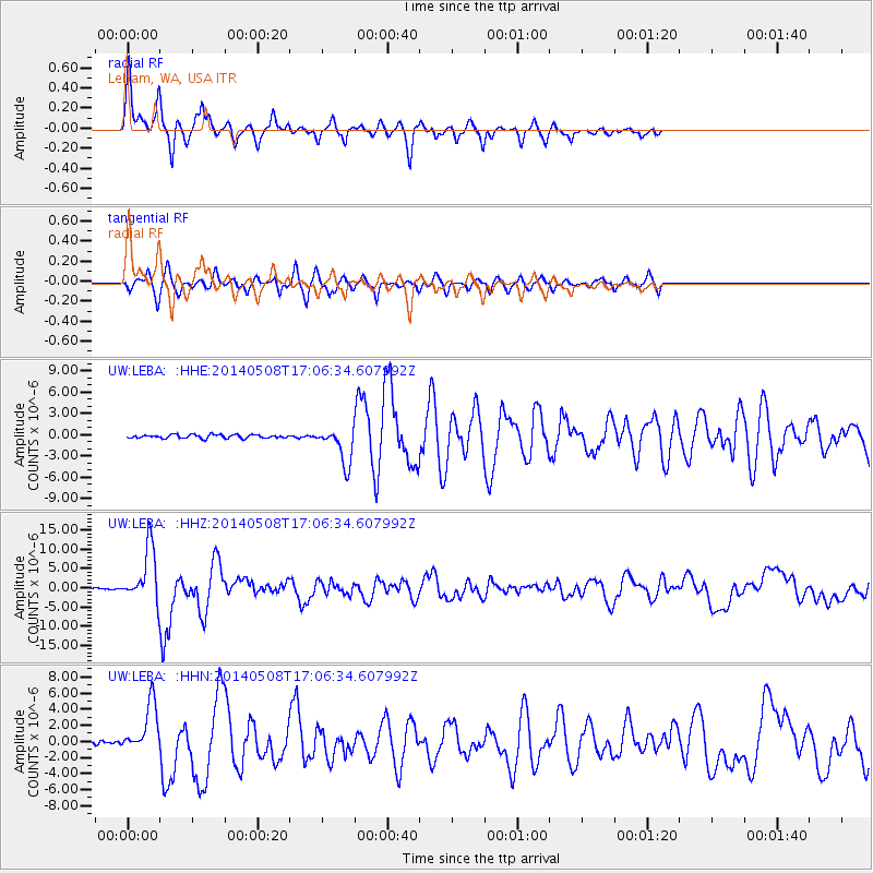
| Radial Match: |
90.35599 % |
| Radial Bump: |
363 |
| Transverse Match: |
72.824745 % |
| Transverse Bump: |
377 |
| SOD ConfigId: |
626651 |
| Insert Time: |
2014-05-22 17:53:26.172 +0000 |
| GWidth: |
2.5 |
| Max Bumps: |
400 |
| Tol: |
0.001 |
|
Signal To Noise
| Channel | StoN | STA | LTA |
| UW:LEBA: :HHZ:20140508T17:06:34.607992Z | 36.343636 | 6.985403E-6 | 1.922043E-7 |
| UW:LEBA: :HHN:20140508T17:06:34.607992Z | 13.956678 | 3.1124207E-6 | 2.2300584E-7 |
| UW:LEBA: :HHE:20140508T17:06:34.607992Z | 10.321549 | 2.5889458E-6 | 2.5082917E-7 |
| Arrivals |
| Ps | 2.0 SECOND |
| PpPs | 5.0 SECOND |
| PsPs/PpSs | 7.0 SECOND |


