You are here: Home > Network List > UW - Pacific Northwest Regional Seismic Network Stations List
> Station LTY Liberty (broad-band) > Earthquake Result Viewer
LTY Liberty (broad-band) - Earthquake Result Viewer
| Earthquake location: |
Guerrero, Mexico |
| Earthquake latitude/longitude: |
17.4/-100.7 |
| Earthquake time(UTC): |
2014/05/08 (128) 17:00:17 GMT |
| Earthquake Depth: |
24 km |
| Earthquake Magnitude: |
6.4 MWW, 6.8 MI |
| Earthquake Catalog/Contributor: |
NEIC PDE/NEIC COMCAT |
|
| Network: |
UW Pacific Northwest Regional Seismic Network |
| Station: |
LTY Liberty (broad-band) |
| Lat/Lon: |
47.26 N/120.66 W |
| Elevation: |
970 m |
|
| Distance: |
34.0 deg |
| Az: |
335.397 deg |
| Baz: |
144.295 deg |
| Ray Param: |
0.0778974 |
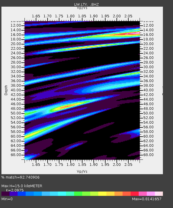
| Estimated Moho Depth: |
15.0 km |
| Estimated Crust Vp/Vs: |
2.10 |
| Assumed Crust Vp: |
6.597 km/s |
| Estimated Crust Vs: |
3.145 km/s |
| Estimated Crust Poisson's Ratio: |
0.35 |
|
| Radial Match: |
92.740906 % |
| Radial Bump: |
345 |
| Transverse Match: |
87.95465 % |
| Transverse Bump: |
368 |
| SOD ConfigId: |
626651 |
| Insert Time: |
2014-05-22 17:53:34.532 +0000 |
| GWidth: |
2.5 |
| Max Bumps: |
400 |
| Tol: |
0.001 |
|

Signal To Noise
| Channel | StoN | STA | LTA |
| UW:LTY: :BHZ:20140508T17:06:28.830007Z | 113.23668 | 7.790281E-6 | 6.8796446E-8 |
| UW:LTY: :BHN:20140508T17:06:28.830007Z | 73.4475 | 4.1665176E-6 | 5.6727835E-8 |
| UW:LTY: :BHE:20140508T17:06:28.830007Z | 16.114344 | 9.121358E-7 | 5.660397E-8 |
| Arrivals |
| Ps | 2.7 SECOND |
| PpPs | 6.6 SECOND |
| PsPs/PpSs | 9.2 SECOND |


