You are here: Home > Network List > II - Global Seismograph Network (GSN - IRIS/IDA) Stations List
> Station KURK Kurchatov, Kazakhstan > Earthquake Result Viewer
KURK Kurchatov, Kazakhstan - Earthquake Result Viewer
| Earthquake location: |
Banda Sea |
| Earthquake latitude/longitude: |
-4.0/128.0 |
| Earthquake time(UTC): |
2001/03/19 (078) 05:52:15 GMT |
| Earthquake Depth: |
33 km |
| Earthquake Magnitude: |
6.0 MB, 6.5 MS, 6.5 MW, 6.5 MW |
| Earthquake Catalog/Contributor: |
WHDF/NEIC |
|
| Network: |
II Global Seismograph Network (GSN - IRIS/IDA) |
| Station: |
KURK Kurchatov, Kazakhstan |
| Lat/Lon: |
50.72 N/78.62 E |
| Elevation: |
184 m |
|
| Distance: |
69.0 deg |
| Az: |
328.861 deg |
| Baz: |
125.761 deg |
| Ray Param: |
0.05590423 |
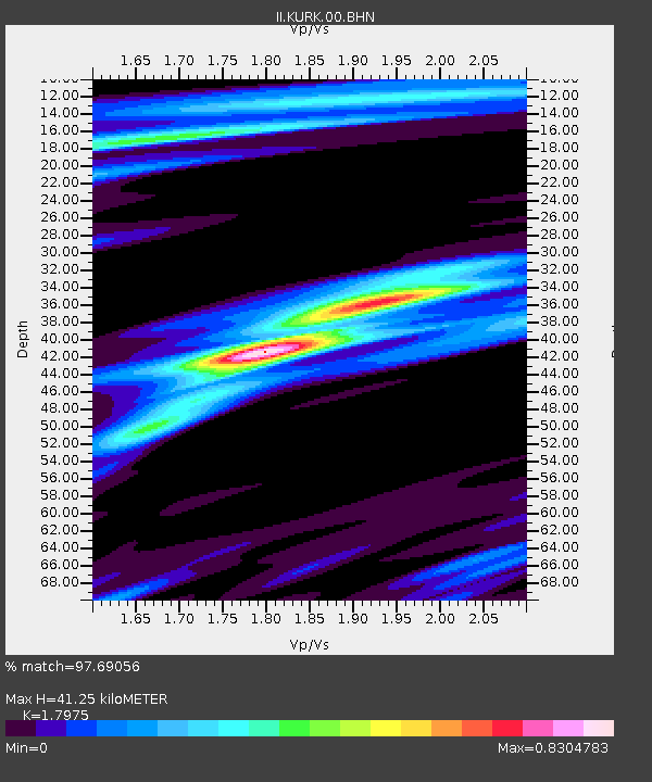
| Estimated Moho Depth: |
41.25 km |
| Estimated Crust Vp/Vs: |
1.80 |
| Assumed Crust Vp: |
6.552 km/s |
| Estimated Crust Vs: |
3.645 km/s |
| Estimated Crust Poisson's Ratio: |
0.28 |
|
| Radial Match: |
97.69056 % |
| Radial Bump: |
296 |
| Transverse Match: |
88.1179 % |
| Transverse Bump: |
400 |
| SOD ConfigId: |
4714 |
| Insert Time: |
2010-03-01 21:55:26.577 +0000 |
| GWidth: |
2.5 |
| Max Bumps: |
400 |
| Tol: |
0.001 |
|

Signal To Noise
| Channel | StoN | STA | LTA |
| II:KURK:00:BHN:20010319T06:02:46.960007Z | 2.736114 | 2.2194325E-7 | 8.111623E-8 |
| II:KURK:00:BHE:20010319T06:02:46.960007Z | 3.6841066 | 1.8877518E-7 | 5.1240423E-8 |
| II:KURK:00:BHZ:20010319T06:02:46.960007Z | 18.16681 | 6.497335E-7 | 3.5764867E-8 |
| Arrivals |
| Ps | 5.2 SECOND |
| PpPs | 17 SECOND |
| PsPs/PpSs | 22 SECOND |


