You are here: Home > Network List > TA - USArray Transportable Network (new EarthScope stations) Stations List
> Station J04D Umpqua National Forest, Toketee, OR, USA > Earthquake Result Viewer
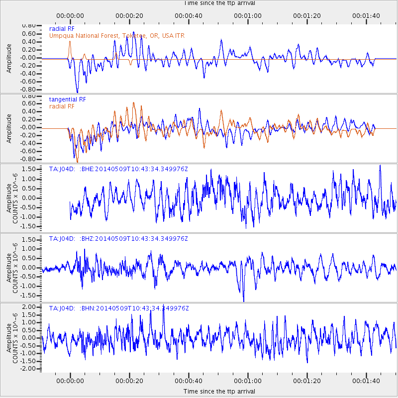
J04D Umpqua National Forest, Toketee, OR, USA - Earthquake Result Viewer
*The percent match for this event was below the threshold and hence no stack was calculated.
| Earthquake location: |
Tonga Islands |
| Earthquake latitude/longitude: |
-18.9/-175.6 |
| Earthquake time(UTC): |
2014/05/09 (129) 10:32:18 GMT |
| Earthquake Depth: |
153 km |
| Earthquake Magnitude: |
5.8 MWP |
| Earthquake Catalog/Contributor: |
NEIC PDE/NEIC COMCAT |
|
| Network: |
TA USArray Transportable Network (new EarthScope stations) |
| Station: |
J04D Umpqua National Forest, Toketee, OR, USA |
| Lat/Lon: |
43.24 N/122.11 W |
| Elevation: |
1948 m |
|
| Distance: |
79.0 deg |
| Az: |
36.76 deg |
| Baz: |
230.826 deg |
| Ray Param: |
$rayparam |
*The percent match for this event was below the threshold and hence was not used in the summary stack. |
|
| Radial Match: |
48.65452 % |
| Radial Bump: |
400 |
| Transverse Match: |
63.919193 % |
| Transverse Bump: |
400 |
| SOD ConfigId: |
626651 |
| Insert Time: |
2014-05-23 11:18:17.322 +0000 |
| GWidth: |
2.5 |
| Max Bumps: |
400 |
| Tol: |
0.001 |
|
Signal To Noise
| Channel | StoN | STA | LTA |
| TA:J04D: :BHZ:20140509T10:43:34.349976Z | 2.903131 | 4.1000231E-7 | 1.4122763E-7 |
| TA:J04D: :BHN:20140509T10:43:34.349976Z | 1.1084684 | 5.339901E-7 | 4.8173683E-7 |
| TA:J04D: :BHE:20140509T10:43:34.349976Z | 1.1889756 | 5.8999854E-7 | 4.962243E-7 |
| Arrivals |
| Ps | |
| PpPs | |
| PsPs/PpSs | |


