You are here: Home > Network List > TA - USArray Transportable Network (new EarthScope stations) Stations List
> Station MDND Maddock, ND, USA > Earthquake Result Viewer
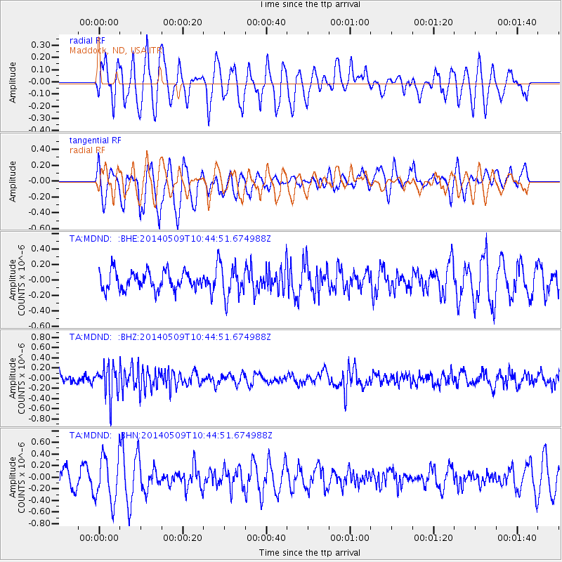
MDND Maddock, ND, USA - Earthquake Result Viewer
*The percent match for this event was below the threshold and hence no stack was calculated.
| Earthquake location: |
Tonga Islands |
| Earthquake latitude/longitude: |
-18.9/-175.6 |
| Earthquake time(UTC): |
2014/05/09 (129) 10:32:18 GMT |
| Earthquake Depth: |
153 km |
| Earthquake Magnitude: |
5.8 MWP |
| Earthquake Catalog/Contributor: |
NEIC PDE/NEIC COMCAT |
|
| Network: |
TA USArray Transportable Network (new EarthScope stations) |
| Station: |
MDND Maddock, ND, USA |
| Lat/Lon: |
47.85 N/99.60 W |
| Elevation: |
479 m |
|
| Distance: |
94.8 deg |
| Az: |
40.986 deg |
| Baz: |
247.184 deg |
| Ray Param: |
$rayparam |
*The percent match for this event was below the threshold and hence was not used in the summary stack. |
|
| Radial Match: |
51.03914 % |
| Radial Bump: |
376 |
| Transverse Match: |
46.693596 % |
| Transverse Bump: |
348 |
| SOD ConfigId: |
626651 |
| Insert Time: |
2014-05-23 11:18:34.791 +0000 |
| GWidth: |
2.5 |
| Max Bumps: |
400 |
| Tol: |
0.001 |
|
Signal To Noise
| Channel | StoN | STA | LTA |
| TA:MDND: :BHZ:20140509T10:44:51.674988Z | 4.001041 | 3.021845E-7 | 7.5526465E-8 |
| TA:MDND: :BHN:20140509T10:44:51.674988Z | 2.3060703 | 4.0469897E-7 | 1.754929E-7 |
| TA:MDND: :BHE:20140509T10:44:51.674988Z | 1.6663084 | 1.9619918E-7 | 1.1774481E-7 |
| Arrivals |
| Ps | |
| PpPs | |
| PsPs/PpSs | |


