You are here: Home > Network List > TA - USArray Transportable Network (new EarthScope stations) Stations List
> Station O03E Paynes Creek, CA, USA > Earthquake Result Viewer
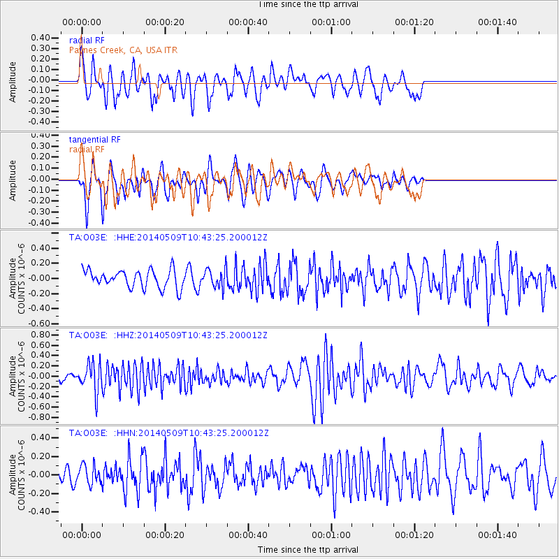
O03E Paynes Creek, CA, USA - Earthquake Result Viewer
*The percent match for this event was below the threshold and hence no stack was calculated.
| Earthquake location: |
Tonga Islands |
| Earthquake latitude/longitude: |
-18.9/-175.6 |
| Earthquake time(UTC): |
2014/05/09 (129) 10:32:18 GMT |
| Earthquake Depth: |
153 km |
| Earthquake Magnitude: |
5.8 MWP |
| Earthquake Catalog/Contributor: |
NEIC PDE/NEIC COMCAT |
|
| Network: |
TA USArray Transportable Network (new EarthScope stations) |
| Station: |
O03E Paynes Creek, CA, USA |
| Lat/Lon: |
40.29 N/121.80 W |
| Elevation: |
967 m |
|
| Distance: |
77.3 deg |
| Az: |
39.251 deg |
| Baz: |
231.542 deg |
| Ray Param: |
$rayparam |
*The percent match for this event was below the threshold and hence was not used in the summary stack. |
|
| Radial Match: |
75.93109 % |
| Radial Bump: |
381 |
| Transverse Match: |
73.40844 % |
| Transverse Bump: |
312 |
| SOD ConfigId: |
626651 |
| Insert Time: |
2014-05-23 11:18:51.785 +0000 |
| GWidth: |
2.5 |
| Max Bumps: |
400 |
| Tol: |
0.001 |
|
Signal To Noise
| Channel | StoN | STA | LTA |
| TA:O03E: :HHZ:20140509T10:43:25.200012Z | 4.7906547 | 2.8664795E-7 | 5.983482E-8 |
| TA:O03E: :HHN:20140509T10:43:25.200012Z | 0.931879 | 1.0370359E-7 | 1.1128439E-7 |
| TA:O03E: :HHE:20140509T10:43:25.200012Z | 1.0835495 | 1.26704E-7 | 1.169342E-7 |
| Arrivals |
| Ps | |
| PpPs | |
| PsPs/PpSs | |


