You are here: Home > Network List > TA - USArray Transportable Network (new EarthScope stations) Stations List
> Station R11A Troy Canyon, Currant, NV, USA > Earthquake Result Viewer
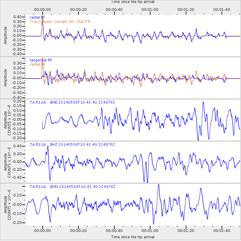
R11A Troy Canyon, Currant, NV, USA - Earthquake Result Viewer
*The percent match for this event was below the threshold and hence no stack was calculated.
| Earthquake location: |
Tonga Islands |
| Earthquake latitude/longitude: |
-18.9/-175.6 |
| Earthquake time(UTC): |
2014/05/09 (129) 10:32:18 GMT |
| Earthquake Depth: |
153 km |
| Earthquake Magnitude: |
5.8 MWP |
| Earthquake Catalog/Contributor: |
NEIC PDE/NEIC COMCAT |
|
| Network: |
TA USArray Transportable Network (new EarthScope stations) |
| Station: |
R11A Troy Canyon, Currant, NV, USA |
| Lat/Lon: |
38.35 N/115.59 W |
| Elevation: |
1756 m |
|
| Distance: |
80.0 deg |
| Az: |
43.744 deg |
| Baz: |
236.352 deg |
| Ray Param: |
$rayparam |
*The percent match for this event was below the threshold and hence was not used in the summary stack. |
|
| Radial Match: |
71.95821 % |
| Radial Bump: |
400 |
| Transverse Match: |
69.02878 % |
| Transverse Bump: |
400 |
| SOD ConfigId: |
626651 |
| Insert Time: |
2014-05-23 11:19:05.595 +0000 |
| GWidth: |
2.5 |
| Max Bumps: |
400 |
| Tol: |
0.001 |
|
Signal To Noise
| Channel | StoN | STA | LTA |
| TA:R11A: :BHZ:20140509T10:43:40.224976Z | 3.5904765 | 2.186701E-7 | 6.0902806E-8 |
| TA:R11A: :BHN:20140509T10:43:40.224976Z | 1.6090456 | 8.525649E-8 | 5.298575E-8 |
| TA:R11A: :BHE:20140509T10:43:40.224976Z | 1.398436 | 5.6619182E-8 | 4.0487507E-8 |
| Arrivals |
| Ps | |
| PpPs | |
| PsPs/PpSs | |


