You are here: Home > Network List > II - Global Seismograph Network (GSN - IRIS/IDA) Stations List
> Station KURK Kurchatov, Kazakhstan > Earthquake Result Viewer
KURK Kurchatov, Kazakhstan - Earthquake Result Viewer

| Earthquake location: |
Mariana Islands |
| Earthquake latitude/longitude: |
18.8/147.0 |
| Earthquake time(UTC): |
2001/06/15 (166) 06:17:45 GMT |
| Earthquake Depth: |
33 km |
| Earthquake Magnitude: |
5.4 MB, 5.9 MS, 6.0 MW, 6.0 MW |
| Earthquake Catalog/Contributor: |
WHDF/NEIC |
|
| Network: |
II Global Seismograph Network (GSN - IRIS/IDA) |
| Station: |
KURK Kurchatov, Kazakhstan |
| Lat/Lon: |
50.72 N/78.62 E |
| Elevation: |
184 m |
|
| Distance: |
62.0 deg |
| Az: |
317.983 deg |
| Baz: |
94.261 deg |
| Ray Param: |
0.06047032 |
| Estimated Moho Depth: |
41.75 km |
| Estimated Crust Vp/Vs: |
1.73 |
| Assumed Crust Vp: |
6.552 km/s |
| Estimated Crust Vs: |
3.799 km/s |
| Estimated Crust Poisson's Ratio: |
0.25 |
|
| Radial Match: |
97.53585 % |
| Radial Bump: |
336 |
| Transverse Match: |
69.932076 % |
| Transverse Bump: |
400 |
| SOD ConfigId: |
4714 |
| Insert Time: |
2010-03-01 21:55:56.277 +0000 |
| GWidth: |
2.5 |
| Max Bumps: |
400 |
| Tol: |
0.001 |
|
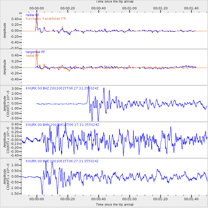
Signal To Noise
| Channel | StoN | STA | LTA |
| II:KURK:00:BHN:20010615T06:27:31.355024Z | 2.20373 | 7.670706E-8 | 3.480783E-8 |
| II:KURK:00:BHE:20010615T06:27:31.355024Z | 20.193012 | 5.066971E-7 | 2.5092694E-8 |
| II:KURK:00:BHZ:20010615T06:27:31.355024Z | 33.179424 | 1.2300732E-6 | 3.7073374E-8 |
| Arrivals |
| Ps | 4.8 SECOND |
| PpPs | 17 SECOND |
| PsPs/PpSs | 21 SECOND |


