You are here: Home > Network List > TA - USArray Transportable Network (new EarthScope stations) Stations List
> Station R11A Troy Canyon, Currant, NV, USA > Earthquake Result Viewer
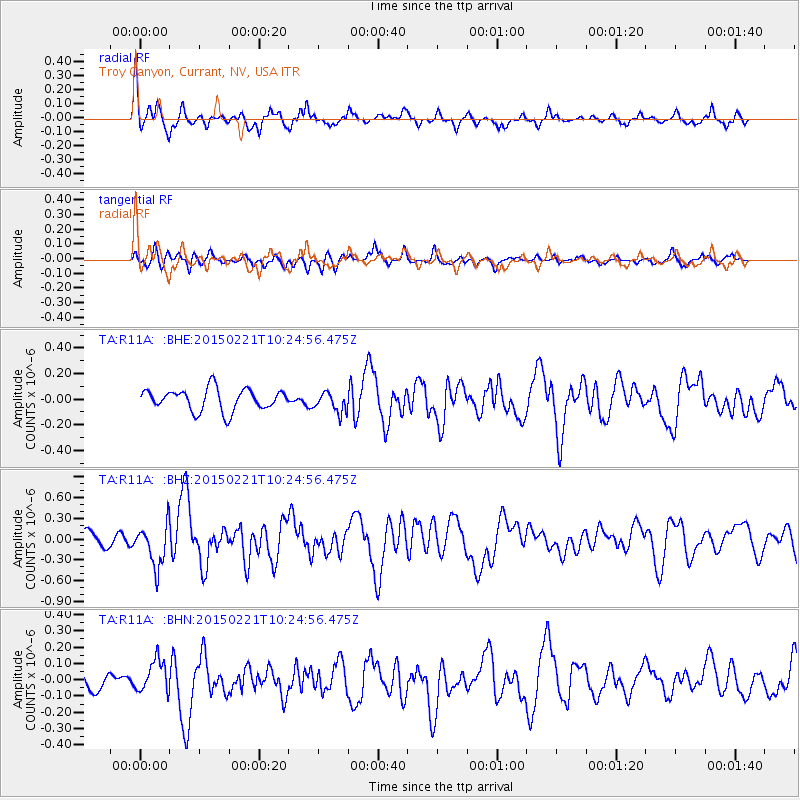
R11A Troy Canyon, Currant, NV, USA - Earthquake Result Viewer
*The percent match for this event was below the threshold and hence no stack was calculated.
| Earthquake location: |
Off East Coast Of Honshu, Japan |
| Earthquake latitude/longitude: |
39.9/143.4 |
| Earthquake time(UTC): |
2015/02/21 (052) 10:13:54 GMT |
| Earthquake Depth: |
10 km |
| Earthquake Magnitude: |
6.1 MO |
| Earthquake Catalog/Contributor: |
NEIC PDE/NEIC ALERT |
|
| Network: |
TA USArray Transportable Network (new EarthScope stations) |
| Station: |
R11A Troy Canyon, Currant, NV, USA |
| Lat/Lon: |
38.35 N/115.59 W |
| Elevation: |
1756 m |
|
| Distance: |
73.8 deg |
| Az: |
53.494 deg |
| Baz: |
308.108 deg |
| Ray Param: |
$rayparam |
*The percent match for this event was below the threshold and hence was not used in the summary stack. |
|
| Radial Match: |
74.45159 % |
| Radial Bump: |
359 |
| Transverse Match: |
56.44521 % |
| Transverse Bump: |
400 |
| SOD ConfigId: |
7019011 |
| Insert Time: |
2019-04-17 00:03:22.792 +0000 |
| GWidth: |
2.5 |
| Max Bumps: |
400 |
| Tol: |
0.001 |
|
Signal To Noise
| Channel | StoN | STA | LTA |
| TA:R11A: :BHZ:20150221T10:24:56.475Z | 3.6710136 | 3.0949272E-7 | 8.430715E-8 |
| TA:R11A: :BHN:20150221T10:24:56.475Z | 1.2458136 | 9.669689E-8 | 7.761746E-8 |
| TA:R11A: :BHE:20150221T10:24:56.475Z | 1.0578116 | 8.8568925E-8 | 8.3728445E-8 |
| Arrivals |
| Ps | |
| PpPs | |
| PsPs/PpSs | |


