You are here: Home > Network List > G - GEOSCOPE Stations List
> Station TAOE Taiohae, Marquises islands > Earthquake Result Viewer
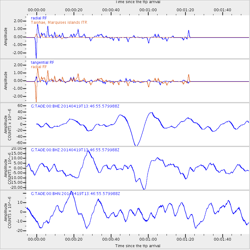
TAOE Taiohae, Marquises islands - Earthquake Result Viewer
*The percent match for this event was below the threshold and hence no stack was calculated.
| Earthquake location: |
Solomon Islands |
| Earthquake latitude/longitude: |
-7.0/155.0 |
| Earthquake time(UTC): |
2014/04/19 (109) 13:36:55 GMT |
| Earthquake Depth: |
35 km |
| Earthquake Magnitude: |
5.5 MB |
| Earthquake Catalog/Contributor: |
NEIC PDE/NEIC COMCAT |
|
| Network: |
G GEOSCOPE |
| Station: |
TAOE Taiohae, Marquises islands |
| Lat/Lon: |
8.85 S/140.15 W |
| Elevation: |
800 m |
|
| Distance: |
64.2 deg |
| Az: |
96.462 deg |
| Baz: |
266.535 deg |
| Ray Param: |
$rayparam |
*The percent match for this event was below the threshold and hence was not used in the summary stack. |
|
| Radial Match: |
52.124897 % |
| Radial Bump: |
400 |
| Transverse Match: |
56.18508 % |
| Transverse Bump: |
324 |
| SOD ConfigId: |
626651 |
| Insert Time: |
2014-05-23 21:01:04.555 +0000 |
| GWidth: |
2.5 |
| Max Bumps: |
400 |
| Tol: |
0.001 |
|
Signal To Noise
| Channel | StoN | STA | LTA |
| G:TAOE:00:BHZ:20140419T13:46:55.579988Z | 1.1744701 | 3.962965E-6 | 3.3742579E-6 |
| G:TAOE:00:BHN:20140419T13:46:55.579988Z | 6.735078 | 1.4011587E-5 | 2.0803898E-6 |
| G:TAOE:00:BHE:20140419T13:46:55.579988Z | 1.3715756 | 1.1037558E-5 | 8.0473565E-6 |
| Arrivals |
| Ps | |
| PpPs | |
| PsPs/PpSs | |


