You are here: Home > Network List > AK - Alaska Regional Network Stations List
> Station BRSE Bradley Lake South, AK, USA > Earthquake Result Viewer
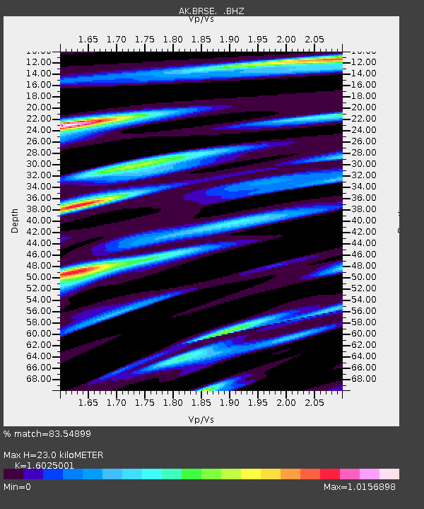
BRSE Bradley Lake South, AK, USA - Earthquake Result Viewer
| Earthquake location: |
Guerrero, Mexico |
| Earthquake latitude/longitude: |
17.3/-100.8 |
| Earthquake time(UTC): |
2014/05/10 (130) 07:36:03 GMT |
| Earthquake Depth: |
35 km |
| Earthquake Magnitude: |
6.0 MB |
| Earthquake Catalog/Contributor: |
NEIC PDE/NEIC COMCAT |
|
| Network: |
AK Alaska Regional Network |
| Station: |
BRSE Bradley Lake South, AK, USA |
| Lat/Lon: |
59.74 N/150.74 W |
| Elevation: |
541 m |
|
| Distance: |
55.6 deg |
| Az: |
331.948 deg |
| Baz: |
117.463 deg |
| Ray Param: |
0.064644866 |
| Estimated Moho Depth: |
23.0 km |
| Estimated Crust Vp/Vs: |
1.60 |
| Assumed Crust Vp: |
6.24 km/s |
| Estimated Crust Vs: |
3.894 km/s |
| Estimated Crust Poisson's Ratio: |
0.18 |
|
| Radial Match: |
83.54899 % |
| Radial Bump: |
400 |
| Transverse Match: |
63.64596 % |
| Transverse Bump: |
400 |
| SOD ConfigId: |
626651 |
| Insert Time: |
2014-05-24 08:06:19.598 +0000 |
| GWidth: |
2.5 |
| Max Bumps: |
400 |
| Tol: |
0.001 |
|

Signal To Noise
| Channel | StoN | STA | LTA |
| AK:BRSE: :BHZ:20140510T07:45:05.168025Z | 10.287482 | 2.1818094E-6 | 2.1208392E-7 |
| AK:BRSE: :BHN:20140510T07:45:05.168025Z | 1.9027184 | 4.5688301E-7 | 2.4012118E-7 |
| AK:BRSE: :BHE:20140510T07:45:05.168025Z | 5.192553 | 9.280882E-7 | 1.7873445E-7 |
| Arrivals |
| Ps | 2.3 SECOND |
| PpPs | 9.1 SECOND |
| PsPs/PpSs | 11 SECOND |


