You are here: Home > Network List > AK - Alaska Regional Network Stations List
> Station EYAK Cordova Ski Area > Earthquake Result Viewer
EYAK Cordova Ski Area - Earthquake Result Viewer
| Earthquake location: |
Guerrero, Mexico |
| Earthquake latitude/longitude: |
17.3/-100.8 |
| Earthquake time(UTC): |
2014/05/10 (130) 07:36:03 GMT |
| Earthquake Depth: |
35 km |
| Earthquake Magnitude: |
6.0 MB |
| Earthquake Catalog/Contributor: |
NEIC PDE/NEIC COMCAT |
|
| Network: |
AK Alaska Regional Network |
| Station: |
EYAK Cordova Ski Area |
| Lat/Lon: |
60.55 N/145.75 W |
| Elevation: |
146 m |
|
| Distance: |
53.8 deg |
| Az: |
334.349 deg |
| Baz: |
123.176 deg |
| Ray Param: |
0.065776676 |
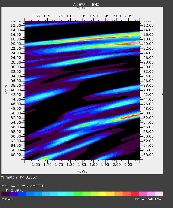
| Estimated Moho Depth: |
19.25 km |
| Estimated Crust Vp/Vs: |
2.10 |
| Assumed Crust Vp: |
6.566 km/s |
| Estimated Crust Vs: |
3.13 km/s |
| Estimated Crust Poisson's Ratio: |
0.35 |
|
| Radial Match: |
94.31557 % |
| Radial Bump: |
400 |
| Transverse Match: |
91.877464 % |
| Transverse Bump: |
316 |
| SOD ConfigId: |
626651 |
| Insert Time: |
2014-05-24 08:07:18.889 +0000 |
| GWidth: |
2.5 |
| Max Bumps: |
400 |
| Tol: |
0.001 |
|

Signal To Noise
| Channel | StoN | STA | LTA |
| AK:EYAK: :BHZ:20140510T07:44:52.52801Z | 61.578278 | 2.8348068E-6 | 4.6035826E-8 |
| AK:EYAK: :BHN:20140510T07:44:52.52801Z | 10.935274 | 1.2562915E-6 | 1.1488432E-7 |
| AK:EYAK: :BHE:20140510T07:44:52.52801Z | 11.126557 | 8.8879307E-7 | 7.988033E-8 |
| Arrivals |
| Ps | 3.4 SECOND |
| PpPs | 8.7 SECOND |
| PsPs/PpSs | 12 SECOND |


