You are here: Home > Network List > AV - Alaska Volcano Observatory Stations List
> Station AU22 Augustine Mound, Augustine Volcano, Alaska > Earthquake Result Viewer
AU22 Augustine Mound, Augustine Volcano, Alaska - Earthquake Result Viewer
| Earthquake location: |
Guerrero, Mexico |
| Earthquake latitude/longitude: |
17.3/-100.8 |
| Earthquake time(UTC): |
2014/05/10 (130) 07:36:03 GMT |
| Earthquake Depth: |
35 km |
| Earthquake Magnitude: |
6.0 MB |
| Earthquake Catalog/Contributor: |
NEIC PDE/NEIC COMCAT |
|
| Network: |
AV Alaska Volcano Observatory |
| Station: |
AU22 Augustine Mound, Augustine Volcano, Alaska |
| Lat/Lon: |
59.34 N/153.36 W |
| Elevation: |
105 m |
|
| Distance: |
56.6 deg |
| Az: |
330.804 deg |
| Baz: |
114.574 deg |
| Ray Param: |
0.063980974 |
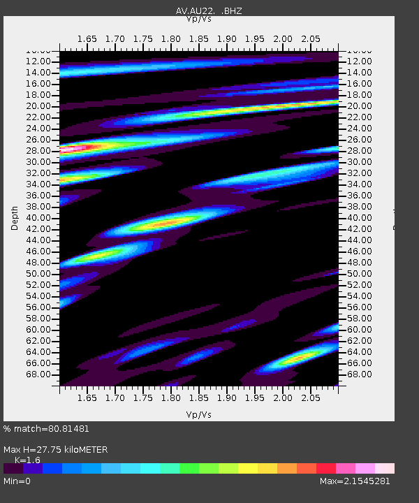
| Estimated Moho Depth: |
27.75 km |
| Estimated Crust Vp/Vs: |
1.60 |
| Assumed Crust Vp: |
5.989 km/s |
| Estimated Crust Vs: |
3.743 km/s |
| Estimated Crust Poisson's Ratio: |
0.18 |
|
| Radial Match: |
80.81481 % |
| Radial Bump: |
400 |
| Transverse Match: |
62.23566 % |
| Transverse Bump: |
400 |
| SOD ConfigId: |
626651 |
| Insert Time: |
2014-05-24 08:13:55.650 +0000 |
| GWidth: |
2.5 |
| Max Bumps: |
400 |
| Tol: |
0.001 |
|

Signal To Noise
| Channel | StoN | STA | LTA |
| AV:AU22: :BHZ:20140510T07:45:12.439998Z | 7.8242645 | 3.1446789E-6 | 4.0191367E-7 |
| AV:AU22: :BHN:20140510T07:45:12.439998Z | 0.88682073 | 8.585522E-7 | 9.681237E-7 |
| AV:AU22: :BHE:20140510T07:45:12.439998Z | 1.9843624 | 1.9969764E-6 | 1.0063567E-6 |
| Arrivals |
| Ps | 2.9 SECOND |
| PpPs | 11 SECOND |
| PsPs/PpSs | 14 SECOND |


