You are here: Home > Network List > BK - Berkeley Digital Seismograph Network Stations List
> Station HUMO Hull Mountain, OR > Earthquake Result Viewer
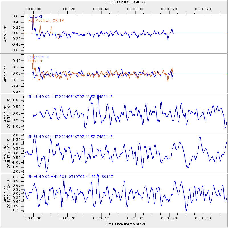
HUMO Hull Mountain, OR - Earthquake Result Viewer
*The percent match for this event was below the threshold and hence no stack was calculated.
| Earthquake location: |
Guerrero, Mexico |
| Earthquake latitude/longitude: |
17.3/-100.8 |
| Earthquake time(UTC): |
2014/05/10 (130) 07:36:03 GMT |
| Earthquake Depth: |
35 km |
| Earthquake Magnitude: |
6.0 MB |
| Earthquake Catalog/Contributor: |
NEIC PDE/NEIC COMCAT |
|
| Network: |
BK Berkeley Digital Seismograph Network |
| Station: |
HUMO Hull Mountain, OR |
| Lat/Lon: |
42.61 N/122.96 W |
| Elevation: |
555 m |
|
| Distance: |
31.6 deg |
| Az: |
327.792 deg |
| Baz: |
136.384 deg |
| Ray Param: |
$rayparam |
*The percent match for this event was below the threshold and hence was not used in the summary stack. |
|
| Radial Match: |
72.101494 % |
| Radial Bump: |
400 |
| Transverse Match: |
49.830757 % |
| Transverse Bump: |
400 |
| SOD ConfigId: |
626651 |
| Insert Time: |
2014-05-24 08:14:31.815 +0000 |
| GWidth: |
2.5 |
| Max Bumps: |
400 |
| Tol: |
0.001 |
|
Signal To Noise
| Channel | StoN | STA | LTA |
| BK:HUMO:00:HHZ:20140510T07:41:52.748011Z | 3.3676379 | 1.1818692E-6 | 3.50949E-7 |
| BK:HUMO:00:HHN:20140510T07:41:52.748011Z | 3.1361127 | 5.561642E-7 | 1.773419E-7 |
| BK:HUMO:00:HHE:20140510T07:41:52.748011Z | 3.1183243 | 7.544582E-7 | 2.4194347E-7 |
| Arrivals |
| Ps | |
| PpPs | |
| PsPs/PpSs | |


