You are here: Home > Network List > CI - Caltech Regional Seismic Network Stations List
> Station VCS Vincent Substation, Palmdale, CA, USA > Earthquake Result Viewer
VCS Vincent Substation, Palmdale, CA, USA - Earthquake Result Viewer
| Earthquake location: |
Near Coast Of Peru |
| Earthquake latitude/longitude: |
-17.7/-71.6 |
| Earthquake time(UTC): |
2001/06/26 (177) 04:18:31 GMT |
| Earthquake Depth: |
24 km |
| Earthquake Magnitude: |
6.2 MB, 6.7 MS, 6.8 MW, 6.7 ME |
| Earthquake Catalog/Contributor: |
WHDF/NEIC |
|
| Network: |
CI Caltech Regional Seismic Network |
| Station: |
VCS Vincent Substation, Palmdale, CA, USA |
| Lat/Lon: |
34.48 N/118.12 W |
| Elevation: |
991 m |
|
| Distance: |
68.2 deg |
| Az: |
319.83 deg |
| Baz: |
131.91 deg |
| Ray Param: |
0.056434482 |
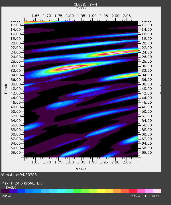
| Estimated Moho Depth: |
24.0 km |
| Estimated Crust Vp/Vs: |
2.00 |
| Assumed Crust Vp: |
6.1 km/s |
| Estimated Crust Vs: |
3.05 km/s |
| Estimated Crust Poisson's Ratio: |
0.33 |
|
| Radial Match: |
94.88795 % |
| Radial Bump: |
400 |
| Transverse Match: |
91.44963 % |
| Transverse Bump: |
400 |
| SOD ConfigId: |
3770 |
| Insert Time: |
2010-02-25 21:04:10.689 +0000 |
| GWidth: |
2.5 |
| Max Bumps: |
400 |
| Tol: |
0.001 |
|
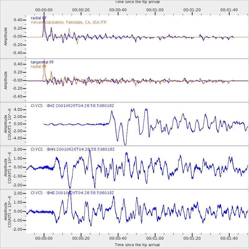
Signal To Noise
| Channel | StoN | STA | LTA |
| CI:VCS: :BHN:20010626T04:28:58.598018Z | 1.4310889 | 1.2239443E-7 | 8.5525386E-8 |
| CI:VCS: :BHE:20010626T04:28:58.598018Z | 0.72259456 | 7.826587E-8 | 1.0831229E-7 |
| CI:VCS: :BHZ:20010626T04:28:58.598018Z | 0.9903645 | 1.1941589E-7 | 1.2057771E-7 |
| Arrivals |
| Ps | 4.1 SECOND |
| PpPs | 11 SECOND |
| PsPs/PpSs | 16 SECOND |


