You are here: Home > Network List > CI - Caltech Regional Seismic Network Stations List
> Station VCS Vincent Substation, Palmdale, CA, USA > Earthquake Result Viewer
VCS Vincent Substation, Palmdale, CA, USA - Earthquake Result Viewer
| Earthquake location: |
Near Coast Of Peru |
| Earthquake latitude/longitude: |
-17.4/-72.2 |
| Earthquake time(UTC): |
2001/06/23 (174) 20:56:07 GMT |
| Earthquake Depth: |
33 km |
| Earthquake Magnitude: |
5.8 MB |
| Earthquake Catalog/Contributor: |
WHDF/NEIC |
|
| Network: |
CI Caltech Regional Seismic Network |
| Station: |
VCS Vincent Substation, Palmdale, CA, USA |
| Lat/Lon: |
34.48 N/118.12 W |
| Elevation: |
991 m |
|
| Distance: |
67.6 deg |
| Az: |
320.049 deg |
| Baz: |
132.08 deg |
| Ray Param: |
0.05679146 |
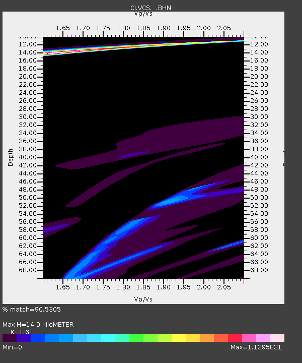
| Estimated Moho Depth: |
14.0 km |
| Estimated Crust Vp/Vs: |
1.61 |
| Assumed Crust Vp: |
6.1 km/s |
| Estimated Crust Vs: |
3.789 km/s |
| Estimated Crust Poisson's Ratio: |
0.19 |
|
| Radial Match: |
90.5305 % |
| Radial Bump: |
304 |
| Transverse Match: |
61.358337 % |
| Transverse Bump: |
400 |
| SOD ConfigId: |
3770 |
| Insert Time: |
2010-02-25 21:04:12.054 +0000 |
| GWidth: |
2.5 |
| Max Bumps: |
400 |
| Tol: |
0.001 |
|

Signal To Noise
| Channel | StoN | STA | LTA |
| CI:VCS: :BHN:20010623T21:06:29.798013Z | 1.0043108 | 6.124695E-5 | 6.0984054E-5 |
| CI:VCS: :BHE:20010623T21:06:29.798013Z | 0.35862327 | 3.3903114E-5 | 9.453685E-5 |
| CI:VCS: :BHZ:20010623T21:06:29.798013Z | 0.77421874 | 4.4984743E-5 | 5.8103404E-5 |
| Arrivals |
| Ps | 1.5 SECOND |
| PpPs | 5.8 SECOND |
| PsPs/PpSs | 7.2 SECOND |


