You are here: Home > Network List > IU - Global Seismograph Network (GSN - IRIS/USGS) Stations List
> Station BILL Bilibino, Russia > Earthquake Result Viewer
BILL Bilibino, Russia - Earthquake Result Viewer

| Earthquake location: |
Guerrero, Mexico |
| Earthquake latitude/longitude: |
17.3/-100.8 |
| Earthquake time(UTC): |
2014/05/10 (130) 07:36:03 GMT |
| Earthquake Depth: |
35 km |
| Earthquake Magnitude: |
6.0 MB |
| Earthquake Catalog/Contributor: |
NEIC PDE/NEIC COMCAT |
|
| Network: |
IU Global Seismograph Network (GSN - IRIS/USGS) |
| Station: |
BILL Bilibino, Russia |
| Lat/Lon: |
68.07 N/166.45 E |
| Elevation: |
320 m |
|
| Distance: |
75.2 deg |
| Az: |
337.158 deg |
| Baz: |
80.836 deg |
| Ray Param: |
0.051793166 |
| Estimated Moho Depth: |
33.25 km |
| Estimated Crust Vp/Vs: |
1.88 |
| Assumed Crust Vp: |
6.577 km/s |
| Estimated Crust Vs: |
3.498 km/s |
| Estimated Crust Poisson's Ratio: |
0.30 |
|
| Radial Match: |
95.41874 % |
| Radial Bump: |
391 |
| Transverse Match: |
91.66899 % |
| Transverse Bump: |
400 |
| SOD ConfigId: |
626651 |
| Insert Time: |
2014-05-24 08:25:57.462 +0000 |
| GWidth: |
2.5 |
| Max Bumps: |
400 |
| Tol: |
0.001 |
|
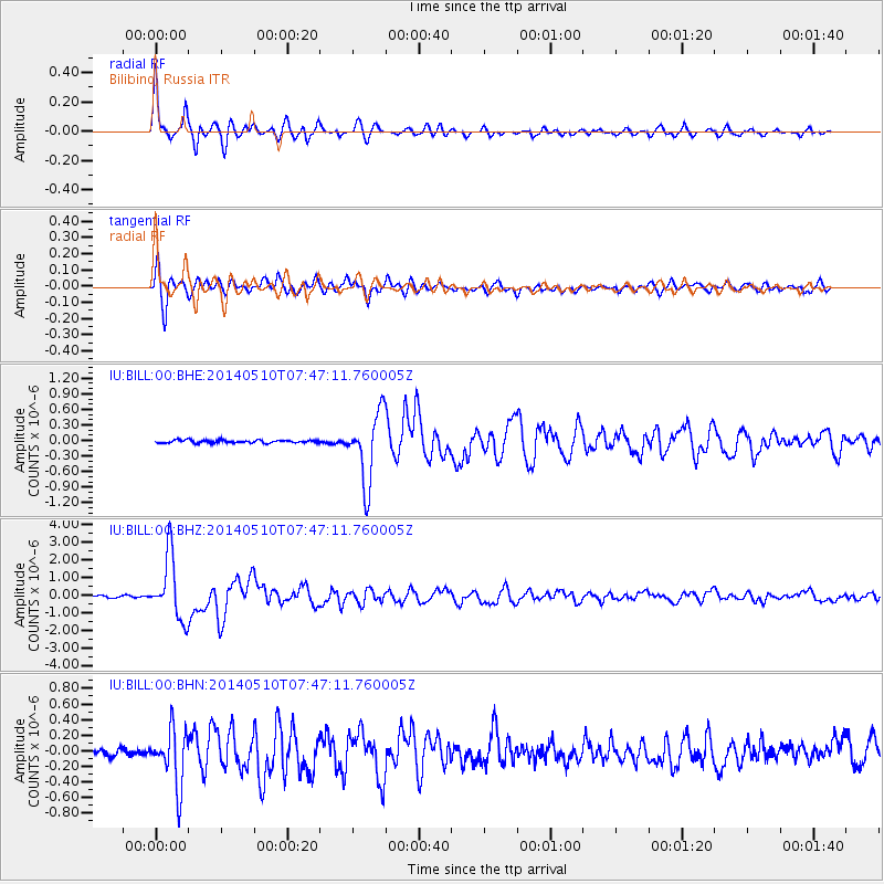
Signal To Noise
| Channel | StoN | STA | LTA |
| IU:BILL:00:BHZ:20140510T07:47:11.760005Z | 43.334175 | 1.7884794E-6 | 4.12718E-8 |
| IU:BILL:00:BHN:20140510T07:47:11.760005Z | 6.8076744 | 3.5856186E-7 | 5.267024E-8 |
| IU:BILL:00:BHE:20140510T07:47:11.760005Z | 23.835833 | 6.6435274E-7 | 2.7872016E-8 |
| Arrivals |
| Ps | 4.6 SECOND |
| PpPs | 14 SECOND |
| PsPs/PpSs | 19 SECOND |


