You are here: Home > Network List > LD - Lamont-Doherty Cooperative Seismographic Network Stations List
> Station HBVT Hinesburg, VT > Earthquake Result Viewer
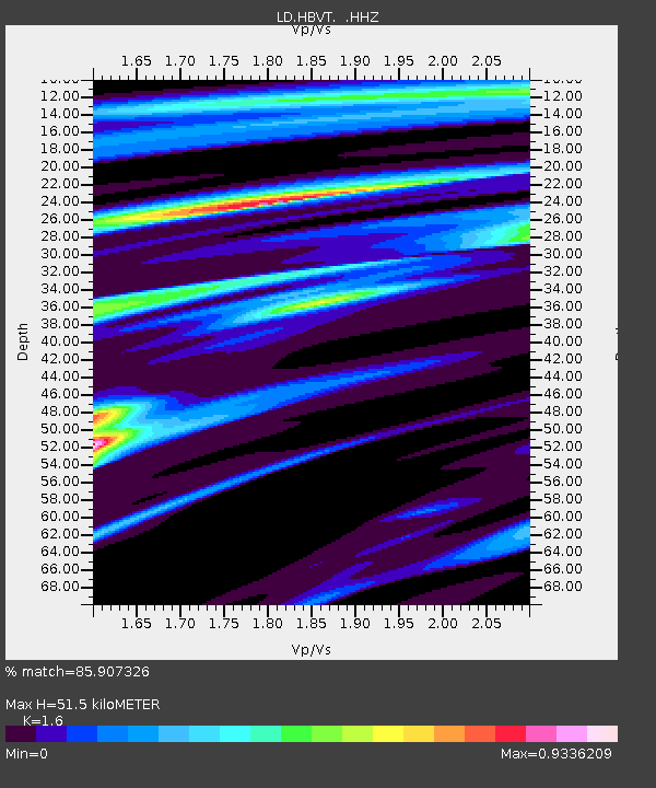
HBVT Hinesburg, VT - Earthquake Result Viewer
| Earthquake location: |
Guerrero, Mexico |
| Earthquake latitude/longitude: |
17.3/-100.8 |
| Earthquake time(UTC): |
2014/05/10 (130) 07:36:03 GMT |
| Earthquake Depth: |
35 km |
| Earthquake Magnitude: |
6.0 MB |
| Earthquake Catalog/Contributor: |
NEIC PDE/NEIC COMCAT |
|
| Network: |
LD Lamont-Doherty Cooperative Seismographic Network |
| Station: |
HBVT Hinesburg, VT |
| Lat/Lon: |
44.36 N/73.07 W |
| Elevation: |
1130 m |
|
| Distance: |
35.7 deg |
| Az: |
34.861 deg |
| Baz: |
229.591 deg |
| Ray Param: |
0.07703199 |
| Estimated Moho Depth: |
51.5 km |
| Estimated Crust Vp/Vs: |
1.60 |
| Assumed Crust Vp: |
6.419 km/s |
| Estimated Crust Vs: |
4.012 km/s |
| Estimated Crust Poisson's Ratio: |
0.18 |
|
| Radial Match: |
85.907326 % |
| Radial Bump: |
303 |
| Transverse Match: |
72.60776 % |
| Transverse Bump: |
400 |
| SOD ConfigId: |
626651 |
| Insert Time: |
2014-05-24 08:28:28.017 +0000 |
| GWidth: |
2.5 |
| Max Bumps: |
400 |
| Tol: |
0.001 |
|

Signal To Noise
| Channel | StoN | STA | LTA |
| LD:HBVT: :HHZ:20140510T07:42:28.364985Z | 22.799871 | 1.8647722E-6 | 8.178872E-8 |
| LD:HBVT: :HHN:20140510T07:42:28.364985Z | 8.909508 | 8.8038297E-7 | 9.881388E-8 |
| LD:HBVT: :HHE:20140510T07:42:28.364985Z | 9.851247 | 1.109165E-6 | 1.1259133E-7 |
| Arrivals |
| Ps | 5.2 SECOND |
| PpPs | 19 SECOND |
| PsPs/PpSs | 24 SECOND |


