You are here: Home > Network List > NE - New England Seismic Network Stations List
> Station EMMW Machias, ME, USA > Earthquake Result Viewer
EMMW Machias, ME, USA - Earthquake Result Viewer
| Earthquake location: |
Guerrero, Mexico |
| Earthquake latitude/longitude: |
17.3/-100.8 |
| Earthquake time(UTC): |
2014/05/10 (130) 07:36:03 GMT |
| Earthquake Depth: |
35 km |
| Earthquake Magnitude: |
6.0 MB |
| Earthquake Catalog/Contributor: |
NEIC PDE/NEIC COMCAT |
|
| Network: |
NE New England Seismic Network |
| Station: |
EMMW Machias, ME, USA |
| Lat/Lon: |
44.71 N/67.46 W |
| Elevation: |
35 m |
|
| Distance: |
39.1 deg |
| Az: |
38.387 deg |
| Baz: |
236.316 deg |
| Ray Param: |
0.07512257 |
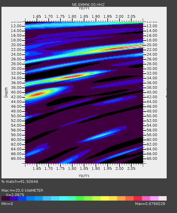
| Estimated Moho Depth: |
20.0 km |
| Estimated Crust Vp/Vs: |
2.10 |
| Assumed Crust Vp: |
6.419 km/s |
| Estimated Crust Vs: |
3.06 km/s |
| Estimated Crust Poisson's Ratio: |
0.35 |
|
| Radial Match: |
91.50846 % |
| Radial Bump: |
194 |
| Transverse Match: |
80.490555 % |
| Transverse Bump: |
400 |
| SOD ConfigId: |
626651 |
| Insert Time: |
2014-05-24 08:32:16.737 +0000 |
| GWidth: |
2.5 |
| Max Bumps: |
400 |
| Tol: |
0.001 |
|

Signal To Noise
| Channel | StoN | STA | LTA |
| NE:EMMW:00:HHZ:20140510T07:42:57.174006Z | 21.740011 | 2.763639E-6 | 1.2712225E-7 |
| NE:EMMW:00:HH1:20140510T07:42:57.174006Z | 10.667303 | 8.907944E-7 | 8.350699E-8 |
| NE:EMMW:00:HH2:20140510T07:42:57.174006Z | 13.803216 | 1.418014E-6 | 1.02730695E-7 |
| Arrivals |
| Ps | 3.6 SECOND |
| PpPs | 9.1 SECOND |
| PsPs/PpSs | 13 SECOND |


