You are here: Home > Network List > NE - New England Seismic Network Stations List
> Station QUA2 Belchertown, MA, USA > Earthquake Result Viewer
QUA2 Belchertown, MA, USA - Earthquake Result Viewer
| Earthquake location: |
Guerrero, Mexico |
| Earthquake latitude/longitude: |
17.3/-100.8 |
| Earthquake time(UTC): |
2014/05/10 (130) 07:36:03 GMT |
| Earthquake Depth: |
35 km |
| Earthquake Magnitude: |
6.0 MB |
| Earthquake Catalog/Contributor: |
NEIC PDE/NEIC COMCAT |
|
| Network: |
NE New England Seismic Network |
| Station: |
QUA2 Belchertown, MA, USA |
| Lat/Lon: |
42.28 N/72.35 W |
| Elevation: |
168 m |
|
| Distance: |
34.8 deg |
| Az: |
38.242 deg |
| Baz: |
232.841 deg |
| Ray Param: |
0.07750543 |
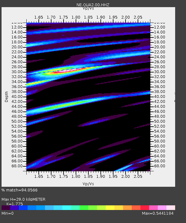
| Estimated Moho Depth: |
29.0 km |
| Estimated Crust Vp/Vs: |
1.77 |
| Assumed Crust Vp: |
6.419 km/s |
| Estimated Crust Vs: |
3.616 km/s |
| Estimated Crust Poisson's Ratio: |
0.27 |
|
| Radial Match: |
94.8566 % |
| Radial Bump: |
307 |
| Transverse Match: |
71.66959 % |
| Transverse Bump: |
400 |
| SOD ConfigId: |
626651 |
| Insert Time: |
2014-05-24 08:32:30.543 +0000 |
| GWidth: |
2.5 |
| Max Bumps: |
400 |
| Tol: |
0.001 |
|

Signal To Noise
| Channel | StoN | STA | LTA |
| NE:QUA2:00:HHZ:20140510T07:42:20.630Z | 29.30966 | 2.4312133E-6 | 8.2949214E-8 |
| NE:QUA2:00:HH1:20140510T07:42:20.630Z | 8.926038 | 9.444527E-7 | 1.05808724E-7 |
| NE:QUA2:00:HH2:20140510T07:42:20.630Z | 17.564075 | 1.3040994E-6 | 7.4248106E-8 |
| Arrivals |
| Ps | 3.8 SECOND |
| PpPs | 12 SECOND |
| PsPs/PpSs | 15 SECOND |


